1900s (20th Century) Maps of Four Buttes, Montana
Explore 4 historic maps of Four Buttes from the 1900s (20th Century). These maps offer a rare glimpse into what life looked like during the 1900s — showing old roads, neighborhoods, homes, and landmarks that have changed or disappeared over time.
Whether you're researching your family's past, planning a metal detecting trip, or studying how Four Buttes's landscape evolved across the 1900s, these high-resolution maps are a powerful tool for exploring the history of this region.
- Focus on a specific era: All maps on this page are from the 1900s, giving you a focused view of this time period.
- See what’s changed: Compare century-old streets, trails, and buildings to today's modern landscape using overlays and satellite layers.
- Research with precision: Use these maps for genealogy, historical research, land use analysis, or educational projects.
- View, download, or print: Maps are fully viewable online in high resolution, and can be downloaded or printed for your own records.
Start exploring Four Buttes's history through authentic maps from the 1900s. This is your window into the past.
Four Buttes, MT maps
(4)- 1954 Map of Wolf Point, 1967 Print
 1954 Wolf Point1967 Print · USGSNortheastern Montana and the North Dakota borderlands are shown here in the mid-fifties, dominated by the Missouri River and the Fort Peck Indian Reservation. Genealogists and historians can trace the Great Northern rail line through river towns like Poplar and Culbertson or locate northern border outposts like the U S Custom Office at Raymond.2 unique versions available
 - 1958 Map of Wolf Point
 1958 Wolf Point1958 Print · USGSNortheastern Montana is shown during the mid-fifties, featuring the extensive Fort Peck Indian Reservation and the Missouri River valley. Researchers can trace the Great Northern railroad through Wolf Point or locate sites like Slab Crossing and the Coal Mine near Medicine Lake.
 - 1973 Map of Four Buttes, 1976 Print
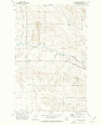 1973 Four Buttes1976 Print · USGSDaniels County was a landscape of rail and ranching in the early seventies, centered on the Four Buttes settlement. You can trace the Burlington Northern line or locate rural landmarks like the Oil Well and La Pierre Coulee.
 - 1983 Map of Scobey, 1984 Print
 1983 Scobey1984 Print · USGSNorthern Montana prairie life during the early eighties centered on the grain-hauling rail lines and the winding Poplar River forks. Genealogists and historians can trace old homesteads near Whitetail, Peerless, and the Fort Peck Indian Reservation Boundary.
End of results
Showing maps 1-4 of 4
Top cities near Four Buttes
Frequently asked questions
- What are the different types of historical maps available for Four Buttes?
- What is the oldest map of Four Buttes?
- Where can I purchase historical maps of Four Buttes for my home or office?
- Where can I download high-res historical maps of Four Buttes?
- Are there historical topographic maps available for Four Buttes?
- Is there historical aerial imagery available for Four Buttes?
- Where are historical maps of Four Buttes sourced from?