1950s Maps of Quintonkon, Montana
Explore 1 historic maps of Quintonkon from the 1950s. These maps offer a rare glimpse into what life looked like during the 1950s — showing old roads, neighborhoods, homes, and landmarks that have changed or disappeared over time.
Whether you're researching your family's past, planning a metal detecting trip, or studying how Quintonkon's landscape evolved across the 1950s, these high-resolution maps are a powerful tool for exploring the history of this region.
- Focus on a specific era: All maps on this page are from the 1950s, giving you a focused view of this time period.
- See what’s changed: Compare century-old streets, trails, and buildings to today's modern landscape using overlays and satellite layers.
- Research with precision: Use these maps for genealogy, historical research, land use analysis, or educational projects.
- View, download, or print: Maps are fully viewable online in high resolution, and can be downloaded or printed for your own records.
Start exploring Quintonkon's history through authentic maps from the 1950s. This is your window into the past.
Quintonkon, MT maps
(1)- 1958 Map of Quintonkon, 1960 Print
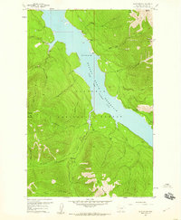 1958 Quintonkon1960 Print · USGSThe South Fork Flathead River valley is shown here just years after being transformed by the Hungry Horse Dam. Researchers can locate remote sites like the Baptiste Grave, early Core Drill Holes, and high-altitude Pack Trails.4 unique versions available
End of results
Showing maps 1-1 of 1
Frequently asked questions
- What are the different types of historical maps available for Quintonkon?
- What is the oldest map of Quintonkon?
- Where can I purchase historical maps of Quintonkon for my home or office?
- Where can I download high-res historical maps of Quintonkon?
- Are there historical topographic maps available for Quintonkon?
- Is there historical aerial imagery available for Quintonkon?
- Where are historical maps of Quintonkon sourced from?