1900s (20th Century) Maps of Quintonkon, Montana
Explore 7 historic maps of Quintonkon from the 1900s (20th Century). These maps offer a rare glimpse into what life looked like during the 1900s — showing old roads, neighborhoods, homes, and landmarks that have changed or disappeared over time.
Whether you're researching your family's past, planning a metal detecting trip, or studying how Quintonkon's landscape evolved across the 1900s, these high-resolution maps are a powerful tool for exploring the history of this region.
- Focus on a specific era: All maps on this page are from the 1900s, giving you a focused view of this time period.
- See what’s changed: Compare century-old streets, trails, and buildings to today's modern landscape using overlays and satellite layers.
- Research with precision: Use these maps for genealogy, historical research, land use analysis, or educational projects.
- View, download, or print: Maps are fully viewable online in high resolution, and can be downloaded or printed for your own records.
Start exploring Quintonkon's history through authentic maps from the 1900s. This is your window into the past.
Quintonkon, MT maps
(7)- 1914 Map of Nyack
 1914 Nyack1914 Print · USGSThe Middle Fork Flathead River corridor is captured here during the early days of Glacier National Park. Historians and researchers can trace the Great Northern rail line through remote stops at Nyack, Essex, and Java.3 unique versions available
 - 1958 Map of Quintonkon, 1960 Print
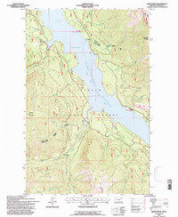
 1958 Quintonkon1960 Print · USGSThe South Fork Flathead River valley is shown here just years after being transformed by the Hungry Horse Dam. Researchers can locate remote sites like the Baptiste Grave, early Core Drill Holes, and high-altitude Pack Trails.4 unique versions available
 - 1960 Map of Cut Bank, 1968 Print
 1960 Cut Bank1968 Print · USGSThe high peaks of the Rockies meet the eastern plains in the 1960s, showing the intersection of federal lands and the Blackfeet Indian Reservation. Trace the path of the Great Northern railway and find local landmarks like the Blackfoot Boarding School and Family Mission Cem.3 unique versions available
 - 1963 Map of Cut Bank
 1963 Cut Bank1963 Print · USGSNorthern Montana’s mountain passes and high plains are captured here in the early 1960s. Genealogists and historians can trace the Great Northern rail stops from Browning to Ethridge or locate the remote outposts at Polebridge and Babb.
 - 1964 Map of Cut Bank
 1964 Cut Bank1964 Print · USGSGlacier National Park and the Blackfeet Indian Reservation meet in the early sixties at the triple divide of North America. Researchers can trace the Great Northern Railway through mountain passes and locate local landmarks like the Blackfoot Boarding School and Apgar Village.
 - 1981 Map of Hungry Horse Reservoir, 1982 Print
 1981 Hungry Horse Reservoir1982 Print · USGSThe Flathead region in the early eighties shows a wilderness managed through rail and reservoir. Genealogists and historians can trace rail-stop settlements like Nyack, Essex, and Summit along the Burlington Northern line and the John F Stevens Canyon.
 - 1994 Map of Quintonkon, 1997 Print
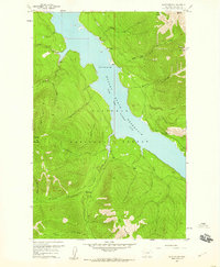
 1994 Quintonkon1997 Print · USGSDeep in the mountains of Flathead County during the mid-nineties, this map reveals the vast Hungry Horse Reservoir and surrounding timberland. Researchers can locate the settlement of Quintonkon and historic markers like the Baptiste Grave.
End of results
Showing maps 1-7 of 7
Frequently asked questions
- What are the different types of historical maps available for Quintonkon?
- What is the oldest map of Quintonkon?
- Where can I purchase historical maps of Quintonkon for my home or office?
- Where can I download high-res historical maps of Quintonkon?
- Are there historical topographic maps available for Quintonkon?
- Is there historical aerial imagery available for Quintonkon?
- Where are historical maps of Quintonkon sourced from?