1980s Maps of Three Forks, Montana
Explore 2 historic maps of Three Forks from the 1980s. These maps offer a rare glimpse into what life looked like during the 1980s — showing old roads, neighborhoods, homes, and landmarks that have changed or disappeared over time.
Whether you're researching your family's past, planning a metal detecting trip, or studying how Three Forks's landscape evolved across the 1980s, these high-resolution maps are a powerful tool for exploring the history of this region.
- Focus on a specific era: All maps on this page are from the 1980s, giving you a focused view of this time period.
- See what’s changed: Compare century-old streets, trails, and buildings to today's modern landscape using overlays and satellite layers.
- Research with precision: Use these maps for genealogy, historical research, land use analysis, or educational projects.
- View, download, or print: Maps are fully viewable online in high resolution, and can be downloaded or printed for your own records.
Start exploring Three Forks's history through authentic maps from the 1980s. This is your window into the past.
Three Forks, MT maps
(2)- 1987 Map of Three Forks
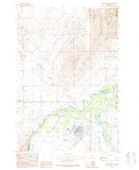 1987 Three Forks1987 Print · USGSThe confluence of the Jefferson, Madison, and Missouri Rivers dominates this 1980s Montana landscape near the Gallatin and Broadwater county line. Researchers can trace the town's industrial footprint through the Grain Elevator, Old RR Grade, and various Mine Shafts in the northern hills.
 - 1987 Map of Three Forks SE
 1987 Three Forks SE1987 Print · USGSGallatin and Broadwater counties meet here in the late 1980s, where the river-fed valley is shaped by a complex network of irrigation and utility. Researchers can trace family-named routes like Buttleman and Crowley or locate the Fairview Cem.
End of results
Showing maps 1-2 of 2
Top cities near Three Forks
Top neighborhoods of Three Forks
Frequently asked questions
- What are the different types of historical maps available for Three Forks?
- What is the oldest map of Three Forks?
- Where can I purchase historical maps of Three Forks for my home or office?
- Where can I download high-res historical maps of Three Forks?
- Are there historical topographic maps available for Three Forks?
- Is there historical aerial imagery available for Three Forks?
- Where are historical maps of Three Forks sourced from?