1990s Maps of Glacier County, Montana
Explore 8 historic maps of Glacier County from the 1990s. These maps offer a rare glimpse into what life looked like during the 1990s — showing old roads, neighborhoods, homes, and landmarks that have changed or disappeared over time.
Whether you're researching your family's past, planning a metal detecting trip, or studying how Glacier County's landscape evolved across the 1990s, these high-resolution maps are a powerful tool for exploring the history of this region.
- Focus on a specific era: All maps on this page are from the 1990s, giving you a focused view of this time period.
- See what’s changed: Compare century-old streets, trails, and buildings to today's modern landscape using overlays and satellite layers.
- Research with precision: Use these maps for genealogy, historical research, land use analysis, or educational projects.
- View, download, or print: Maps are fully viewable online in high resolution, and can be downloaded or printed for your own records.
Start exploring Glacier County's history through authentic maps from the 1990s. This is your window into the past.
Glacier County, MT maps
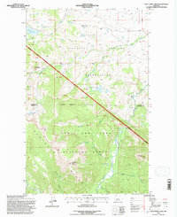
(8)- 1994 Map of Blacktail, 1997 Print
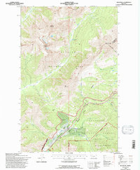 1994 Blacktail1997 Print · USGSGlacier National Park and the surrounding Flathead forestlands are captured here in the mid-1990s as the rail corridor remained a vital artery. Trace the mountain crossings of the Burlington Northern through Theodore Roosevelt Pass and find remote sites like the Fielding Patrol Cabin.
 - 1994 Map of Lake Mc Donald East, 1997 Print
 1994 Lake Mc Donald East1997 Print · USGSGlacier National Park in the mid-1990s reveals a high-alpine landscape of interconnected trails and historic backcountry stations. Researchers can trace the routes around Sperry Chalets, the crossing at Crystal Ford, and the ascent to Gunsight Pass.
 - 1995 Map of East Glacier Park, 1997 Print
 1995 East Glacier Park1997 Print · USGSThe eastern gateway to the Rockies comes into focus during the mid-1990s as the railroad and highway cross the Continental Divide. Researchers can trace the layout of East Glacier Park, locate the East Glacier Park Cem, and follow the Burlington Northern line through Theodore Roosevelt Pass.
 - 1995 Map of Squaw Mountain, 1997 Print
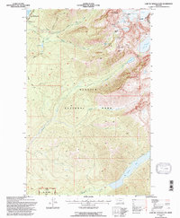
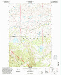
 1995 Squaw Mountain1997 Print · USGSGlacier National Park and the Blackfeet Indian Reservation meet along the Continental Divide in the mid-1990s. Researchers can trace the Burlington Northern Railroad through Bison or locate backcountry landmarks like Running Eagle Falls and Scenic Point.
 - 1995 Map of Half Dome Crag, 1997 Print
 1995 Half Dome Crag1997 Print · USGSThe high peaks of the eastern Rockies meet the western edge of the Blackfeet lands in the mid-nineties. Researchers can trace the drainage of Slippery Hoof Creek, locate the Palookaville (Site), or find landmarks like the Magee Ranch.
 - 1995 Map of Summit, 1997 Print
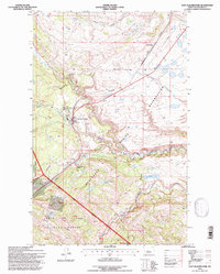
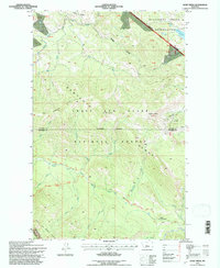
 1995 Summit1997 Print · USGSMarias Pass and the Continental Divide define this Montana high-country survey from the mid-nineties. Trace the high-altitude route of the Burlington Northern railroad past the Summit settlement and through Theodore Roosevelt Pass.
 - 1995 Map of Hyde Creek, 1997 Print
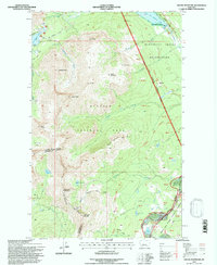
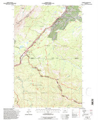
 1995 Hyde Creek1997 Print · USGSThe Lewis and Clark Range meets the Blackfeet Indian Reservation in the mid-1990s, showcasing a landscape defined by mountain ridges and river headwaters. Researchers can trace remote routes like the Continental Divide National Scenic Trail and locate the Badger Guard Station.
 - 1995 Map of Mitten Lake, 1997 Print
 1995 Mitten Lake1997 Print · USGSThe Blackfeet Reservation and Lewis and Clark National Forest meet in the Montana high country during the mid-nineties. You can trace early educational footprints at Swims Under Sch and navigate the high-elevation waters of Mitten Lake and Horn Lake.
End of results
Showing maps 1-8 of 8
Top cities of Glacier County
Frequently asked questions
- What are the different types of historical maps available for Glacier County?
- What is the oldest map of Glacier County?
- Where can I purchase historical maps of Glacier County for my home or office?
- Where can I download high-res historical maps of Glacier County?
- Are there historical topographic maps available for Glacier County?
- Is there historical aerial imagery available for Glacier County?
- Where are historical maps of Glacier County sourced from?