Old Maps of Glacier County, Montana for Hiking & Exploration
Hike through history with 506 historic maps of Glacier County. Explore old trails, ghost towns, and forgotten backroads — perfect for outdoor adventurers and local explorers.
- Rediscover forgotten places: Map out old mining camps, roads, and footpaths that no longer exist on modern maps.
- Layer with modern tools: Combine with LiDAR or satellite views to plan hikes through historical terrain.
- Made for exploration: Popular among hikers, overlanders, and local history lovers.
Use these maps to find adventure and explore the hidden past of Glacier County.
Glacier County, MT maps
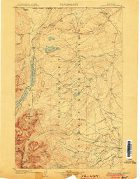
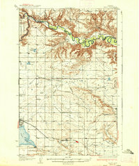
(506)- 1901 Map of Browning, 1959 Print
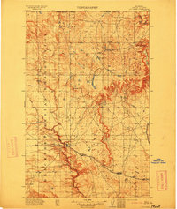
 1901 Browning1959 Print · USGSThe Blackfeet Indian Reservation and eastern Glacier National Park meet in this early twentieth-century survey. Genealogists and historians can trace old homesteads and landmarks like Galbreath Ranch, the Pontresina Sch, and the Great Northern rail corridor.
 - 1903 Map of Browning
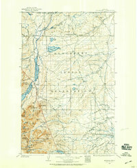
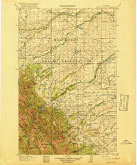
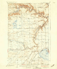
 1903 Browning1903 Print · USGSThe Blackfeet Reservation and the high peaks of northern Montana appear here shortly after the turn of the century. You can trace the path of the Great Northern R. R. through Browning or locate early settlements like St. Mary along the glacial lakes.2 unique versions available
 - 1904 Map of Chief Mountain
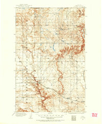
 1904 Chief Mountain1904 Print · USGSThe northern Rockies at the dawn of the century were a rugged borderland of forest reserves and tribal lands. Researchers can trace early outposts like Kipps Cabin and Altyn, or locate family-named sites including Rogers Ranch and Geduhn's.8 unique versions available
 - 1906 Map of Kintla Lakes
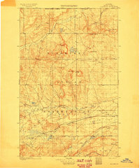
 1906 Kintla Lakes1906 Print · USGSThe high peaks of the northern Rockies appear in sharp relief during the first years of the century, just south of the Canadian border. Genealogists and historians can locate early homesteads like Jefferson's Ranch and Christensen's Ranch alongside glacial features like Agassiz Glacier.4 unique versions available
 - 1907 Map of Blackfoot Res.
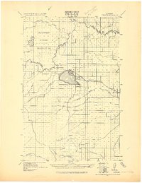
 1907 Blackfoot Res.1907 Print · USGSEarly twentieth-century northern Montana terrain comes into focus through this technical reclamation survey. Genealogists and researchers can trace the precise contours of the land across T.34 N. and T.32 N., locating specific early benchmarks like BM 3775.
 - 1909 Map of Cut Bank, 1955 Print
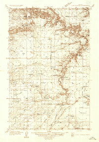
 1909 Cut Bank1955 Print · USGSHigh plains settlement and rail expansion define this Teton County landscape during the early twentieth century. Genealogists can trace the early rail stops of the Great Northern at Cut Bank, Ethridge, and Simla near the Blackfeet Indian Reservation boundary.
 - 1911 Map of Blackfoot
 1911 Blackfoot1911 Print · USGSNorthwestern Montana at the start of the twentieth century was a territory of vast open spaces and burgeoning rail towns. Researchers can trace the early Great Northern railroad corridor through Blackfoot, find the Cutfinger School, and locate Cooks Ranch.2 unique versions available
 - 1912 Map of Cut Bank
 1912 Cut Bank1912 Print · USGSNorthern Montana’s high plains and the Blackfeet Indian Reservation are captured here during the height of the homesteading era. Genealogists and historians can trace the early path of the Great Northern R R through Cut Bank and Simla.3 unique versions available
 - 1913 Map of Marias Pass
 1913 Marias Pass1913 Print · USGSThe Continental Divide and the Great Northern Railroad meet at the crest of the Rockies in the years just after Glacier's establishment. Local historians can trace early rail stations like Lubec, the Midvale settlement, and remote outposts such as Three Forks Rangers Cabin.3 unique versions available
 - 1914 Map of Heart Butte, 1959 Print
 1914 Heart Butte1959 Print · USGSThe foothills and plains of Pondera and Teton Counties are captured here in the early 1900s as the wilderness was being organized by early forestry and ranching. Genealogists can trace early homestead life via the Terryman School, Family, and the Blackleaf Ranger Station.
 - 1918 Map of Heart Butte
 1918 Heart Butte1918 Print · USGSThe northern Montana plains meet the high Divide in the early twentieth century, showing the interface of the Blackfeet Indian Reservation and the national forest. Genealogists and historians can locate early rural schools like Jensen School and frontier outposts such as Hagans Crossing and the Blackleaf Ranger Station.3 unique versions available
 - 1920 Map of Dupuyer
 1920 Dupuyer1920 Print · USGSHigh plains ranching and early irrigation projects define this 1920s survey of the Montana frontier. Genealogists and historians can trace the early rail stops and homestead hubs at Valier, Pendroy, and Manson along the Montana Western R. R. line.
 - 1934 Map of Lake Frances
 1934 Lake Frances1934 Print · USGSThe Blackfeet Reservation and Pondera County come alive in the mid-1930s, showing a complex network of canals and family ranching. Genealogists can trace family holdings like Wolsfad Ranch or locate the Lakeview Cem and several coal mines including the Slezic Mine.
 - 1934 Map of Valier, 1962 Print
 1934 Valier1962 Print · USGSThe northern Montana plains come alive in the 1930s as a hub of irrigation and rail at the edge of the Blackfeet Indian Reservation. Genealogists can trace family holdings and local landmarks like Belgian Ch, Valier, and the Montana Western railroad terminus.2 unique versions available
 - 1937 Map of Valier
 1937 Valier1937 Print · USGSPondera County’s irrigation-driven agriculture is in full bloom during the mid-1930s as the Montana Western railroad serves the prairie. Genealogists can locate family holdings like Parker Ranch and trace the many local school districts such as Winginaw Valley Sch or Lone Tree Sch.2 unique versions available
 - 1937 Map of Lake Frances
 1937 Lake Frances1937 Print · USGSThe high plains of Pondera County come alive in the mid-1930s as irrigation projects and small-scale coal mining reshape the landscape. Genealogists and local historians can locate specific homesteads like Bartley Ranch, find long-forgotten mines including Blair Mine, or trace the grounds of the Lakeview Cem and State Fish Hatchery.3 unique versions available
 - 1938 Map of Chief Mountain, 1953 Print
 1938 Chief Mountain1953 Print · USGSGlacier National Park and the neighboring Blackfeet Indian Reservation are shown here during the late thirties as the modern highway system was taking shape. You can trace the early tourism and management landscape through Going-to-the-Sun Chalet, Many Glacier, and the remote Sperry Chalet.8 unique versions available
 - 1938 Map of Kintla Lakes, 1954 Print
 1938 Kintla Lakes1954 Print · USGSThe northern reaches of the Montana Rockies are shown here during the early years of the National Park Service. Researchers can locate early homesteads and remote outposts like Brills Ranch, Polebridge, and Theo Christensen Ranch along the Flathead River.
 - 1957 Map of Kalispell, 1967 Print
 1957 Kalispell1967 Print · USGSNorthwest Montana in the late fifties showcases a mountain landscape transitioning between wilderness and industry. Genealogists and researchers can trace the Great Northern rail corridor through Kalispell and Whitefish, or locate landmarks like the Montana Soldiers Home and Hungry Horse Reservoir.3 unique versions available
 - 1960 Map of Kalispell
 1960 Kalispell1960 Print · USGSNorthwest Montana in the late fifties is defined by the mountain corridors of the Great Northern Railway and the vast reaches of Glacier National Park. Researchers can trace the legacy of timber and mining towns like Libby, Rexford, and Whitefish, or locate landmarks such as the Snowshoe Mine.
 - 1960 Map of Cut Bank, 1968 Print
 1960 Cut Bank1968 Print · USGSThe high peaks of the Rockies meet the eastern plains in the 1960s, showing the intersection of federal lands and the Blackfeet Indian Reservation. Trace the path of the Great Northern railway and find local landmarks like the Blackfoot Boarding School and Family Mission Cem.3 unique versions available
 - 1961 Map of Kalispell
 1961 Kalispell1961 Print · USGSNorthwestern Montana at the start of the 1960s shows a landscape of timber-driven rail towns and the sprawling wild lands of Glacier National Park. Genealogists and historians can trace the route of the Great Northern through mountain passes or locate old settlements like Fortine, Trego, and Warland.
 - 1963 Map of Cut Bank
 1963 Cut Bank1963 Print · USGSNorthern Montana’s mountain passes and high plains are captured here in the early 1960s. Genealogists and historians can trace the Great Northern rail stops from Browning to Ethridge or locate the remote outposts at Polebridge and Babb.
 - 1964 Map of Cut Bank
 1964 Cut Bank1964 Print · USGSGlacier National Park and the Blackfeet Indian Reservation meet in the early sixties at the triple divide of North America. Researchers can trace the Great Northern Railway through mountain passes and locate local landmarks like the Blackfoot Boarding School and Apgar Village.
 - 1966 Map of Ethridge NW, 1969 Print
 1966 Ethridge NW1969 Print · USGSToole County's high plains and resource economy are captured here during the mid-1960s. Genealogists and industrial historians can trace early petroleum sites like Oil Wells and Gas Wells, as well as the path of the Pipeline through Sand Coulee.
Showing maps 1-25 of 506
Top cities of Glacier County
Frequently asked questions
- What are the different types of historical maps available for Glacier County?
- What is the oldest map of Glacier County?
- Where can I purchase historical maps of Glacier County for my home or office?
- Where can I download high-res historical maps of Glacier County?
- Are there historical topographic maps available for Glacier County?
- Is there historical aerial imagery available for Glacier County?
- Where are historical maps of Glacier County sourced from?