Old Maps of Golden Valley County, Montana for Genealogy
Trace your family roots with 226 historic maps of Golden Valley County. These high-res maps reveal old neighborhoods, homesites, landmarks, and streets — helping you uncover where your ancestors lived and how the area evolved over time.
- Explore historic neighborhoods: Identify where your relatives may have lived in the 1800s or 1900s.
- Compare maps over time: Trace the changes in streets, buildings, and landmarks for multi-generational research.
- Perfect for genealogy & ancestry research: Used by family historians and researchers to map out lineage and migration.
These maps are an incredible resource for exploring your personal connection to Golden Valley County's past.
Golden Valley County, MT maps
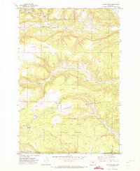
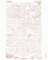
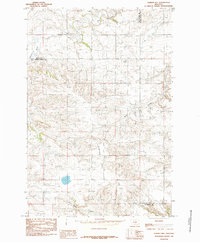
(226)- 1889 Map of Big Snowy Mountain
 1889 Big Snowy Mountain1889 Print · USGSCentral Montana in the late 1880s was a land of critical mountain passes and emerging frontier outposts. You can trace early settlement patterns and cattle country geography through historic sites like Ubet, Bercail, and Melville near the Musselshell River.
 - 1893 Map of Big Snowy Mountain
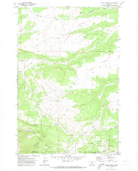
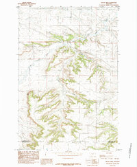
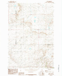
 1893 Big Snowy Mountain1893 Print · USGSCentral Montana in the late frontier era reveals a landscape shaped by the massive Big Snowy Mountain and the headwaters of major rivers. Researchers can trace early settlements and transit points like Ubet, Judith Gap, and the remote outpost of Bercail.4 unique versions available
 - 1954 Map of Roundup, 1966 Print
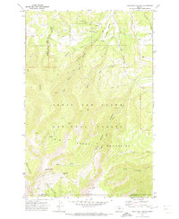
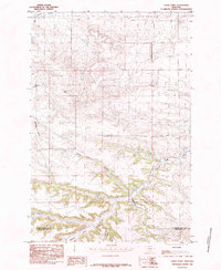
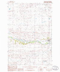
 1954 Roundup1966 Print · USGSCentral Montana in the mid-1960s showcases a landscape of high-plains agriculture and vital rail connections. Researchers can trace historic routes through Harlowton and Roundup while locating landmarks like Judith Cemetery and Deadmans Basin Reservoir.2 unique versions available
 - 1958 Map of Roundup
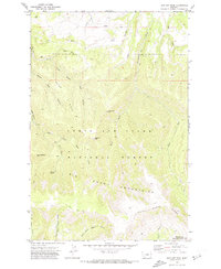
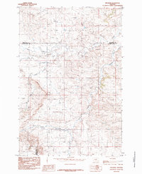
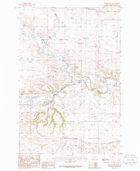
 1958 Roundup1958 Print · USGSCentral Montana ranching and rail infrastructure are captured here in the late fifties as the Musselshell River valley thrived. Researchers can trace the Great Northern line through Harlowton or locate the Judith Cemetery and Gage Community.2 unique versions available
 - 1970 Map of South Bench, 1973 Print
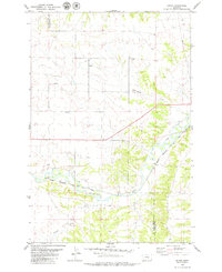
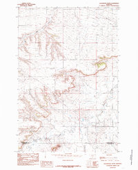
 1970 South Bench1973 Print · USGSFergus and Golden Valley counties in the early seventies reveal a high-plains landscape where the Little Snowy Mountains meet the central Montana benches. Researchers can trace land use near Ashbridge Spring, locate a remote Cem, and explore the headwaters of North Fork Flatwillow Creek.
 - 1970 Map of Alaska Bench, 1973 Print
 1970 Alaska Bench1973 Print · USGSFergus County in the early seventies is a landscape of high plateaus and deep canyons at the edge of the mountains. Local historians can trace the isolated settlement of Holt and the winding path of Red Hill Road through the Lewis and Clark National Forest.
 - 1970 Map of Half Moon Canyon, 1973 Print
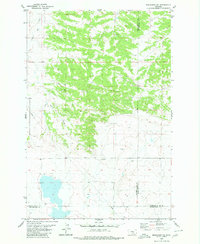
 1970 Half Moon Canyon1973 Print · USGSThe Big Snowy Mountains of central Montana appear here as a remote wilderness at the start of the 1970s. Researchers can trace historic access routes and water sources like the Lewis Ranch, Half Moon Pass, and the high-altitude Greathouse Peak.2 unique versions available
 - 1970 Map of Jump Off Peak, 1974 Print
 1970 Jump Off Peak1974 Print · USGSThe Big Snowy Mountains of Central Montana are shown here in the 1970s, marking a wilderness landscape defined by sharp ridges and deep canyons. Follow old Pack Trails to high-elevation landmarks like Jump off Peak, Mount Harlow, and the Crystal Cascades.
 - 1979 Map of Roundup
 1979 Roundup1979 Print · USGSCentral Montana at the close of the 1970s reveals a landscape defined by coal mining and major rail lines. Researchers can trace the industrial legacy of Roundup and Klein or locate landmarks like the Western Mine and Steamboat Butte.
 - 1979 Map of Bundy
 1979 Bundy1979 Print · USGSCentral Montana cattle and rail country is captured here in the late seventies as the river and railway define local life. Genealogists and historians can trace the irrigation systems of Glennie Ditch, the railroad siding at Bundy, and the rugged terrain of Painted Robe.
 - 1979 Map of Lavina NW
 1979 Lavina NW1979 Print · USGSGolden Valley and Musselshell Counties in the late seventies show a landscape shaped by drainage and light industry. Researchers can trace the path of a major Pipeline, locate several Gravel Pits, and follow the winding courses of Currant Creek and Twin Coulee.
 - 1979 Map of Timber Buttes South, 1980 Print
 1979 Timber Buttes South1980 Print · USGSThe Musselshell and Golden Valley county line is captured in the late seventies, showing a landscape defined by ranching and mineral potential. Trace the drainage paths of Pole Creek and Cameron Creek or locate landmarks like Timber Buttes and the local Gravel Pit.
 - 1979 Map of Lavina, 1980 Print
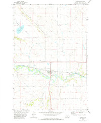 1979 Lavina1980 Print · USGSIn the late 1970s, the Musselshell River valley near Lavina remained a hub of rail and river activity. Researchers can trace the path of the Chicago Milwaukee St Paul and Pacific and local landmarks like the Rodeo Ground.
 - 1979 Map of Belmont, 1980 Print
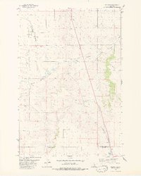 1979 Belmont1980 Print · USGSGolden Valley County in the late seventies is captured here at a time when the Burlington Northern railroad and cattle-country hydrology defined the local economy. Researchers can trace the rail corridor through the Painted Robe Tunnel and locate rural landmarks like Belmont and Alkali Pond.2 unique versions available
 - 1980 Map of Broadview NE
 1980 Broadview NE1980 Print · USGSGolden Valley and Musselshell counties meet in this 1980 survey of the Montana high plains during a period of steady rural development. Researchers can trace land use patterns along the banks of Painted Robe Creek and Spring Creek or locate industrial markers like the Pipeline and Gravel Pit.
 - 1985 Map of Locomotive Butte
 1985 Locomotive Butte1985 Print · USGSThe rugged boundary between Golden Valley and Stillwater counties is captured here in the mid-1980s. Researchers can trace the water and utility infrastructure of the era, from a Pumping Station and Pipeline to a Flowing Well near Big Coulee Creek.
 - 1985 Map of Jim Creek
 1985 Jim Creek1985 Print · USGSThe Montana plains near the three-county corner of Wheatland, Sweet Grass, and Golden Valley are captured here during the mid-1980s. Researchers can trace the varied topography of the Cayuse Hills and the winding paths of Jim Creek and Potato Creek.
 - 1985 Map of Locomotive Butte SW
 1985 Locomotive Butte SW1985 Print · USGSThe triple-border intersection of Golden Valley, Sweet Grass, and Stillwater counties is captured here in the mid-1980s. Researchers can trace the winding paths of Sixshooter Creek and Whitney Creek or locate the prominent rise of Knob Hill.
 - 1985 Map of Mount Sinai
 1985 Mount Sinai1985 Print · USGSGolden Valley and Stillwater counties are captured in the mid-1980s, revealing a landscape of high ridges and deep drainages. Researchers can trace the rugged topography from Mount Sinai down through Big Coulee Creek and Custer Creek to find old trails and property lines.
 - 1985 Map of Eagle Point
 1985 Eagle Point1985 Print · USGSThe high plains of the Montana borderlands come into focus in the mid-1980s, revealing a landscape of dramatic buttes and winding coulees. Researchers can trace the drainages of Painted Robe Creek and locate landmarks like Antelope Butte and Stockade Gulch.
 - 1985 Map of Progress
 1985 Progress1985 Print · USGSThe ranchlands of central Montana come into focus in the mid-1980s, centered on the small settlement of Progress. Researchers can trace the winding paths of Fish Creek and Simmons Creek or locate landmarks like Chinemans Hat and the local Gravel Pit.
 - 1985 Map of O'Brien Hill
 1985 O'Brien Hill1985 Print · USGSThe high plains of Golden Valley County come into focus during the mid-eighties, showing a landscape defined by water rights and rugged topography. Researchers can trace the drainages of Fish Creek and Rock Creek or locate isolated wells and springs near O'Brien Hill.
 - 1985 Map of Gibson
 1985 Gibson1985 Print · USGSGolden Valley and Sweet Grass counties are captured in the mid-1980s, centered on the rural settlement of Gibson. Genealogists and historians can trace the intricate waterways of North Fork Big Coulee Creek and Sixshooter Creek across this high-plains landscape.
 - 1986 Map of Ryegate West
 1986 Ryegate West1986 Print · USGSGolden Valley County in the mid-1980s shows a landscape shaped by the Musselshell River and early transport routes. Genealogists and historians can trace the town of Ryegate, the settlement of Franklin, and the Old RR Grade.
 - 1986 Map of Ryegate East
 1986 Ryegate East1986 Print · USGSGolden Valley near the mid-eighties shows a landscape defined by the winding Musselshell River and the small-town hub of Ryegate. Researchers can trace the legacy of local transport via the Old RR Grade and find landmarks like the Landing Strip.
Showing maps 1-25 of 226
Top cities of Golden Valley County
Frequently asked questions
- What are the different types of historical maps available for Golden Valley County?
- What is the oldest map of Golden Valley County?
- Where can I purchase historical maps of Golden Valley County for my home or office?
- Where can I download high-res historical maps of Golden Valley County?
- Are there historical topographic maps available for Golden Valley County?
- Is there historical aerial imagery available for Golden Valley County?
- Where are historical maps of Golden Valley County sourced from?