1900s (20th Century) Maps of Packers, Montana
Explore 9 historic maps of Packers from the 1900s (20th Century). These maps offer a rare glimpse into what life looked like during the 1900s — showing old roads, neighborhoods, homes, and landmarks that have changed or disappeared over time.
Whether you're researching your family's past, planning a metal detecting trip, or studying how Packers's landscape evolved across the 1900s, these high-resolution maps are a powerful tool for exploring the history of this region.
- Focus on a specific era: All maps on this page are from the 1900s, giving you a focused view of this time period.
- See what’s changed: Compare century-old streets, trails, and buildings to today's modern landscape using overlays and satellite layers.
- Research with precision: Use these maps for genealogy, historical research, land use analysis, or educational projects.
- View, download, or print: Maps are fully viewable online in high resolution, and can be downloaded or printed for your own records.
Start exploring Packers's history through authentic maps from the 1900s. This is your window into the past.
Packers, MT maps
(9)- 1903 Map of Coopers Lake
 1903 Coopers Lake1903 Print · USGSLewis and Clark and Powell counties are shown at the turn of the century as the high-mountain ranching and mining frontier expanded. Genealogists and researchers can locate family landmarks like Lunds Ranch, Witmer Bros Ranch, and the Klondike Mine.3 unique versions available
 - 1955 Map of Choteau, 1978 Print
 1955 Choteau1978 Print · USGSWestern Montana during the mid-fifties is captured here as a land of rugged high-country wilderness and vital eastern plains irrigation. Genealogists and historians can locate remote outposts like Condon, the communal Miller Colony, and the rail stops of the Chicago Milwaukee St Paul and Pacific.
 - 1957 Map of Choteau
 1957 Choteau1957 Print · USGSMontana's mountain front meets the eastern plains in the mid-fifties, showing the transition from forested wilderness to irrigated ranch land. Genealogists and historians can trace the rail lines of the Great Northern and find settlements like Choteau, Augusta, and Seeley Lake.
 - 1958 Map of Choteau
 1958 Choteau1958 Print · USGSMontana's front range meets the high wilderness in the late fifties, where the Great Northern railway connects ranching towns to the eastern plains. Researchers can trace the development of irrigation at Bynum Reservoir or locate remote camps like the Big Prairie District Ranger Station and Helmville.2 unique versions available
 - 1962 Map of Choteau
 1962 Choteau1962 Print · USGSThe Rocky Mountain Front meets the western plains in the early 1960s, showing a landscape defined by the Continental Divide. Genealogists and researchers can trace the tracks of the Great Northern and find settlements like Choteau, Augusta, and Bynum.
 - 1970 Map of Benchmark, 1973 Print
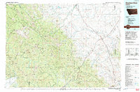
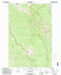
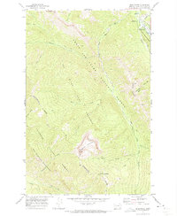 1970 Benchmark1973 Print · USGSThe Montana wilderness around the Sun River was a hub of backcountry activity in the 1970s. Researchers can trace the network of pack trails and remote outposts like the Benchmark Work Center, Benchmark Airfield, and the Patrol Mountain lookout.2 unique versions available
 - 1976 Map of Choteau
 1976 Choteau1976 Print · USGSThe Montana Rocky Mountain Front meets the plains in the 1970s, showcasing the high-altitude wilderness and the irrigation-fed ranching country. Trace the Great Northern Railway through Choteau or locate rural landmarks like the Farmington Cemetery and Gibson Reservoir.
 - 1993 Map of Dearborn River
 1993 Dearborn River1993 Print · USGSThe Montana wilderness and the Front Range come alive in this early 1990s overview of the high country near Augusta. Outdoor historians and researchers can trace the Continental Divide Trail or locate remote sites like Copper Camp and Milford Colony.
 - 1995 Map of Benchmark, 1997 Print
 1995 Benchmark1997 Print · USGSThe Montana backcountry along the Continental Divide comes into focus in the mid-1990s, where federal wilderness areas and game preserves meet. Researchers can locate remote outposts like the Benchmark Airfield, the station at Fairview, and the high Lookout on Patrol Mountain.
End of results
Showing maps 1-9 of 9
Frequently asked questions
- What are the different types of historical maps available for Packers?
- What is the oldest map of Packers?
- Where can I purchase historical maps of Packers for my home or office?
- Where can I download high-res historical maps of Packers?
- Are there historical topographic maps available for Packers?
- Is there historical aerial imagery available for Packers?
- Where are historical maps of Packers sourced from?