1990s Maps of Mineral County, Montana
Explore 42 historic maps of Mineral County from the 1990s. These maps offer a rare glimpse into what life looked like during the 1990s — showing old roads, neighborhoods, homes, and landmarks that have changed or disappeared over time.
Whether you're researching your family's past, planning a metal detecting trip, or studying how Mineral County's landscape evolved across the 1990s, these high-resolution maps are a powerful tool for exploring the history of this region.
- Focus on a specific era: All maps on this page are from the 1990s, giving you a focused view of this time period.
- See what’s changed: Compare century-old streets, trails, and buildings to today's modern landscape using overlays and satellite layers.
- Research with precision: Use these maps for genealogy, historical research, land use analysis, or educational projects.
- View, download, or print: Maps are fully viewable online in high resolution, and can be downloaded or printed for your own records.
Start exploring Mineral County's history through authentic maps from the 1990s. This is your window into the past.
Mineral County, MT maps
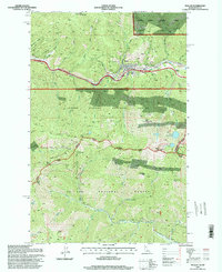
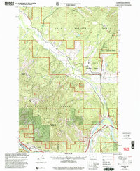
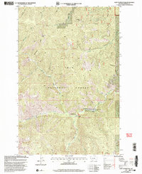
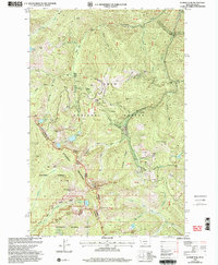
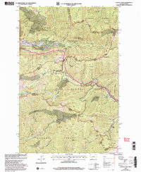
(42)- 1994 Map of Wallace
 1994 Wallace1994 Print · USGSThe Bitterroot Mountains and the mining heart of the Silver Valley are captured here in the mid-1990s. Researchers can locate active and historic mineral operations such as the Argentine Mine and Last Chance Mines, while tracing the Milwaukee Road through the high passes.
 - 1994 Map of Rhodes Peak, 1997 Print
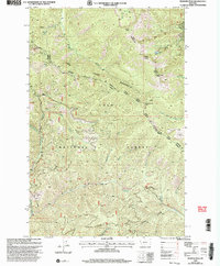
 1994 Rhodes Peak1997 Print · USGSThe Bitterroot mountains of the mid-1990s are mapped here at the height of their forest-management era along the Idaho-Montana line. Researchers can locate remote high-country landmarks like Rhodes Peak, the Black Lead mining area, and a lonely Grave near Billy Rhodes Creek.
 - 1994 Map of Hoodoo Pass, 1997 Print
 1994 Hoodoo Pass1997 Print · USGSThe high Bitterroot divide between Idaho and Montana is captured here in the mid-1990s, where national forest boundaries meet at the crest. Researchers can trace the remote network of ridge roads and alpine waters, from the Radio Tower at Hoodoo Pass to the headwaters of the North Fork Clearwater River.
 - 1994 Map of Bruin Hill, 1997 Print
 1994 Bruin Hill1997 Print · USGSThe Bitterroot backcountry along the Idaho-Montana line is captured here in the mid-1990s as a vast network of forest ridges and alpine basins. Researchers can trace the rugged drainage systems of Japanese Creek or locate remote landmarks like Siamese Lakes and Bruin Hill.
 - 1994 Map of Granite Pass, 1997 Print
 1994 Granite Pass1997 Print · USGSThe Bitterroot Range divide comes into sharp focus during the mid-1990s, tracing the remote border between Idaho and Montana. Researchers can follow the winding State Line Trail across high summits like Granite Peak and through Granite Pass.
 - 1995 Map of Sherlock Peak, 1997 Print
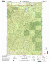
 1995 Sherlock Peak1997 Print · USGSThe Montana-Idaho border highlands are revealed in this mid-nineties survey, showing the confluence of three national forests. Researchers can trace historical high-country land use through the Gold Nugget Mine and the remote Grave Heller Creek site.
 - 1995 Map of Adair, 1997 Print
 1995 Adair1997 Print · USGSThe high Bitterroot ridges along the Idaho and Montana border are captured here in the mid-nineties. You can trace the Old RR Grade through the mountains, locate the Adair (Site), and find remote industrial markers like the Hecla Mines.
 - 1995 Map of Berge Peak, 1997 Print
 1995 Berge Peak1997 Print · USGSThe Bitterroot Range divide where Idaho meets Montana is captured here in the mid-nineties, showing the intersection of the St Joe and Lolo national forests. Hikers and historians can trace high-altitude landmarks like Berge Peak, Moore Lake, and the remote Avery Superior Rd.
 - 1995 Map of Mullan, 1998 Print
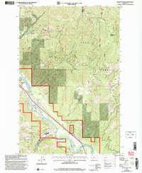
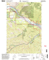
 1995 Mullan1998 Print · USGSMullan and the surrounding Silver Valley are shown here in the mid-1990s as a high-altitude industrial hub. Researchers can trace the legacy of the local mining economy through landmarks like the Lucky Friday Mine, the Morning Mine, and the Old RR Grade.
 - 1999 Map of Idaho Gulch, 2003 Print
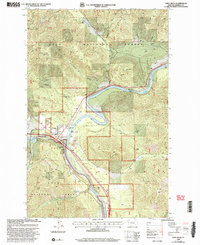
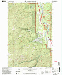
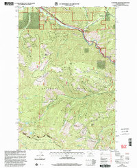
 1999 Idaho Gulch2003 Print · USGSThe Clark Fork valley and the rugged Ninemile Divide define this part of Mineral County at the close of the twentieth century. Researchers can trace the boundaries of Lolo National Forest, locate the County Airport, and identify the settlement of Oliverville.
 - 1999 Map of De Borgia North, 2003 Print
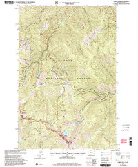
 1999 De Borgia North2003 Print · USGSMineral County's high ridges and deep timber come into focus at the end of the century, centered on the settlement of De Borgia. Local historians can trace old mining claims like the Copper Rock Mine and Rock Island Mine or locate high-country landmarks like Knox Pass.
 - 1999 Map of Saint Regis, 2003 Print
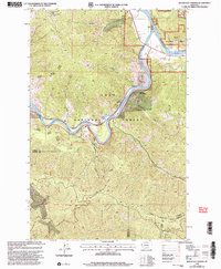
 1999 Saint Regis2003 Print · USGSThe mountain town of St Regis appears at the turn of the millennium as a vital forestry and travel hub along the Clark Fork. Researchers can trace the local infrastructure of the era, from the St Regis Work Center and Heliport to the town Cem.
 - 1999 Map of Alberton, 2003 Print
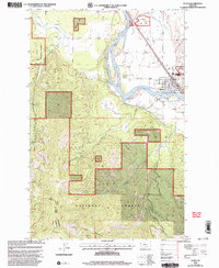
 1999 Alberton2003 Print · USGSThe Mineral County mountainside meets the Clark Fork valley at the close of the twentieth century. Researchers can trace the legacy of forest management and early transport through the Ninemile Remount Depot, the CCC Campsite, and the winding Discovery Trail.
 - 1999 Map of Penrose Peak, 2003 Print
 1999 Penrose Peak2003 Print · USGSThe Coeur d'Alene Mountains of western Montana are shown in detail during the late nineties, defined by the administrative divide between the Thompson Falls and Superior districts. Researchers can locate remote high-country landmarks like Acorn Lake, the summit of Penrose Peak, and signs of old mining activity at a lone Adit.
 - 1999 Map of Lozeau, 2003 Print
 1999 Lozeau2003 Print · USGSMineral County, Montana, is defined by the river and forest in the late nineties as this survey captures the corridor near the Clark Fork. Researchers can trace the small settlements of Lozeau and Westfall, locate a local Cem, or find historic Mine sites near Sunrise Creek.
 - 1999 Map of Torino Peak, 2003 Print
 1999 Torino Peak2003 Print · USGSHigh in the Bitterroot Range at the turn of the millennium, this survey captures the wild boundary between Montana and Idaho. Trace the paths of the Superior Red Ives Ranger District Trail past Cliff Lake and the peak at Little Joe Mountain.
 - 1999 Map of Saint Patrick Peak, 2003 Print
 1999 Saint Patrick Peak2003 Print · USGSMineral County's high-altitude backcountry is detailed here in the final years of the twentieth century. Researchers can trace the trails and infrastructure of the Lolo National Forest, including the Clearwater Crossing FS Ranger Station, the Hide-in-the-Wall Lodge, and the summit of St Patrick Peak.
 - 1999 Map of Superior, 2003 Print
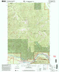
 1999 Superior2003 Print · USGSThe Clark Fork river valley and the town of Superior are captured here in the late nineties as centers of mountain recreation and forest management. Researchers can trace local landmarks like La Vista, the Cem, and the Superior Ranger District Office.
 - 1999 Map of Deer Peak, 2003 Print
 1999 Deer Peak2003 Print · USGSThe Mineral and Missoula county line near the end of the twentieth century shows a landscape of deep timber and steep drainages. Trace high-altitude landmarks like Deer Peak Lookout and localized settlements such as Hebert along Sawmill Gulch.
 - 1999 Map of Quinns Hot Springs, 2003 Print
 1999 Quinns Hot Springs2003 Print · USGSThe confluence of the Flathead River and Clark Fork is captured in the late 1990s as a hub for both mountain recreation and historic industry. Local historians can trace the paths of the Old Pardee Trail, the location of the Hopkins Mine, and early developments at Quinns Hot Springs.
 - 1999 Map of Illinois Peak, 2003 Print
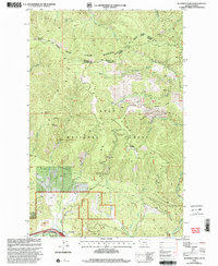
 1999 Illinois Peak2003 Print · USGSThe Bitterroot Mountains of the late nineties are shown here at the height of their mining and forest management era. You can trace the locations of historic lode claims and camps like the Silver King Mine, La Casse Camp, and Gildersleeve Mine.
 - 1999 Map of De Borgia South, 2003 Print
 1999 De Borgia South2003 Print · USGSThe Bitterroot Mountains at the Montana-Idaho border are captured here in the late 1990s as a landscape of deep national forests and remote mining sites. Historians can trace the Aladdin Mine or the Drexel (Site) alongside high-altitude landmarks like the Up Up Mountain Lookout.
 - 1999 Map of Stark South, 2003 Print
 1999 Stark South2003 Print · USGSThe Clark Fork corridor and the Lolo National Forest interior are captured here at the close of the twentieth century. Researchers can trace the rugged topography from Stark Mountain Lookout down to river landmarks like the Natural Pier Bridge and Stark.
 - 1999 Map of Plains, 2003 Print
 1999 Plains2003 Print · USGSThe Clark Fork river valley and the town of Plains are captured here in the late twentieth century, showing a community defined by its timber and river-valley roots. Researchers can trace the town's footprint from the Fairground to the Cem, or head into the mountains to find Mines and the Plains Seed Orchard.
 - 1999 Map of Lookout Pass, 2003 Print
 1999 Lookout Pass2003 Print · USGSThe Bitterroot Range summit at the turn of the millennium shows the enduring legacy of mining and the evolution of mountain transit. Trace the routes of the Milwaukee Road and discover the locations of the Snowstorm Mine and Bullion Mine.
Showing maps 1-25 of 42
Top cities of Mineral County
Frequently asked questions
- What are the different types of historical maps available for Mineral County?
- What is the oldest map of Mineral County?
- Where can I purchase historical maps of Mineral County for my home or office?
- Where can I download high-res historical maps of Mineral County?
- Are there historical topographic maps available for Mineral County?
- Is there historical aerial imagery available for Mineral County?
- Where are historical maps of Mineral County sourced from?