Old Maps of Mineral County, Montana for Metal Detecting
Plan your next treasure hunt with 317 historic maps of Mineral County. Find old homesites, ghost towns, trails, and gathering spots that may be lost to time — perfect for identifying promising metal detecting locations.
- Locate forgotten sites: Uncover places like long-lost settlements, abandoned rail lines, or gathering spots.
- Plan better hunts: Use map overlays combined with LiDAR or satellite views to narrow in on historically rich areas.
- Made for detectorists: Thousands of hobbyists use these maps to discover relics, coins, and hidden history.
Use these historic maps to boost your research and find new opportunities beneath the surface of Mineral County.
Mineral County, MT maps
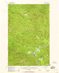
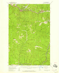
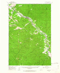
(317)- 1901 Map of Coeur D'Alene District, 1954 Print
 1901 Coeur D'Alene District1954 Print · USGSIdaho's Silver Valley hums with industrial activity at the turn of the century as silver and lead mining reach their peak. Genealogists and historians can trace the deep-vein claims of the Bunker Hill and Sullivan Mine or the narrow-canyon settlements of Burke and Mace.
 - 1903 Map of Coeur D'Alene District
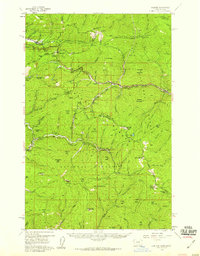
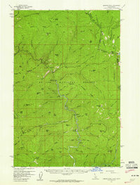
 1903 Coeur D'Alene District1903 Print · USGSThe Silver Valley was at its industrial peak at the start of the century, defined by a dense network of silver and lead operations. Genealogists and historians can trace early rail lines and major works like the Standard Mines, Gem Mine, and the town of Wardner.
 - 1906 Map of Coeur D'Alene District
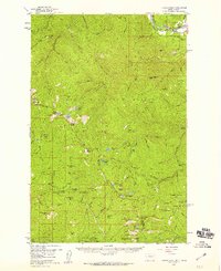
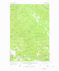
 1906 Coeur D'Alene District1906 Print · USGSIdaho’s Silver Valley is shown at its industrial peak in the early twentieth century, when mines and railroads saturated these steep canyons. Genealogists and researchers can trace the rail lines to remote mining camps and famous works like the Hecla Mine, Bunker Hill and Sullivan Mines, and Burke.3 unique versions available
 - 1911 Map of Lolo, 1954 Print
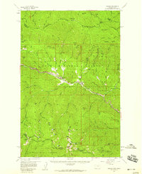
 1911 Lolo1954 Print · USGSThe Bitterroot wilderness at the dawn of the Forest Service era is documented here through its early camps and trail networks. Researchers can locate remote outposts like Moose City, the Clearwater Gold and Copper Company, and the historic Indian Post Office landmark.
 - 1912 Map of Missoula
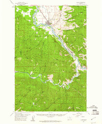
 1912 Missoula1912 Print · USGSWestern Montana at the end of the frontier era shows a landscape of growing rail hubs and remote mountain outposts. Researchers can trace early river crossings like Alberts Ferry, the grounds of Ft Missoula, and vanished schools such as Big Flat School.4 unique versions available
 - 1913 Map of Lolo
 1913 Lolo1913 Print · USGSThe Bitterroot wilderness of the early 1900s is documented here through a web of mining camps, ranger stations, and high mountain passes. Genealogists and researchers can locate remote sites like Moose City, Williams Ranch, and the Clearwater Gold and Copper Company.2 unique versions available
 - 1914 Map of Avery, 1954 Print
 1914 Avery1954 Print · USGSThe Bitterroot Range was a hive of mining and rail activity when this survey was conducted. You can trace the Chicago Milwaukee and St Paul Railway route or locate early mining operations like the Snowstorm Mine and Mastodon Mine.
 - 1917 Map of Avery, 1949 Print
 1917 Avery1949 Print · USGSThe mining camps and mountain passes of the Idaho-Montana border are documented here just after the peak of the regional silver and lead boom. You can trace the path of the Milwaukee St Paul and Pacific RR or locate historic claims like the Snowstorm Mine and Monitor Mine.
 - 1918 Map of St Regis, 1946 Print
 1918 St Regis1946 Print · USGSMineral County, Montana, was a bustling corridor for mining and rail traffic during the early twentieth century. Researchers can trace the path of the Northern Pacific through St Regis or locate remote sites like the Gold Crown Mine and Gold Nugget Cabin.
 - 1919 Map of St. Regis
 1919 St. Regis1919 Print · USGSThe Montana-Idaho borderlands were a hub of mountain mining and transcontinental railroading during the early twentieth century. Genealogists and historians can locate remote settlements like DeBorgia and Henderson or trace old mining operations such as the Saltese Consolidated Mine and Gold Crown Mine.
 - 1956 Map of St Regis, 1958 Print
 1956 St Regis1958 Print · USGSMineral County in the mid-fifties is defined by the vital rail and river junction at the foot of the Coeur d'Alene Mountains. Genealogists and historians can trace early transport routes like Mullan Road and find remote stations such as Camel's Hump Lookout Sta and Toole.3 unique versions available
 - 1956 Map of Saltese, 1959 Print
 1956 Saltese1959 Print · USGSThe Montana-Idaho border highlands are captured here in the mid-1950s, showing a rugged landscape defined by heavy industry and mountain transit. Genealogists and historians can trace the deep-seated mining heritage through the Silver Cable Mine, the historic Old Mullan Road, and the isolated rail stop at Roland.3 unique versions available
 - 1956 Map of Wallace, 1966 Print
 1956 Wallace1966 Print · USGSWestern Montana and the Idaho panhandle meet in this mid-century survey of the Bitterroot and Cabinet Mountains. Genealogists and historians can trace the rail-and-river economy through the Northern Pacific line and settlements like Thompson Falls or St. Ignatius.3 unique versions available
 - 1956 Map of Hamilton, 1970 Print
 1956 Hamilton1970 Print · USGSThe Bitterroot Valley and surrounding high country are captured here during the mid-fifties, showing the region's transition into a modern forest-and-rail hub. Genealogists and historians can trace family-named sites and early infrastructure from Fort Missoula to towns like Stevensville and Darby along the Northern Pacific line.2 unique versions available
 - 1957 Map of Illinois Peak, 1959 Print
 1957 Illinois Peak1959 Print · USGSThe Bitterroot and Coeur d'Alene mountain ranges meet in the late fifties at this junction of three National Forests. Prospectors and local historians can trace legacy mining claims like the Silver King Mine and Gildersleeve Mine near Illinois Peak.2 unique versions available
 - 1957 Map of Haugan, 1959 Print
 1957 Haugan1959 Print · USGSMineral County mining and railroading are at their peak in the late fifties as two major rail lines traverse the St. Regis River valley. Genealogists and historians can locate old mountain settlements like De Borgia and trace the proximity of the Saltese Consolidated Mine to early forest service outposts like Up Up Lookout.2 unique versions available
 - 1957 Map of Wallace, 1959 Print
 1957 Wallace1959 Print · USGSShoshone County mining towns and the rugged St. Joe watershed are frozen in time during the late fifties. Genealogists and industrial historians can trace the foundations of the Silver Valley via the Miners Union Cemetery, Morning Mine, and the Milwaukee Road.3 unique versions available
 - 1957 Map of Simmons Peak, 1959 Print
 1957 Simmons Peak1959 Print · USGSThe Idaho-Montana borderlands are captured here in the mid-fifties, featuring the high ridges of the Bitterroot Range. Researchers can trace the early Forest Service footprint at the Red Ives Ranger Sta or locate historic camps like Gold Creek Campground.2 unique versions available
 - 1959 Map of Hamilton
 1959 Hamilton1959 Print · USGSThe Bitterroot Valley and surrounding wilderness are captured in the late fifties, showing a landscape defined by forestry and river-based settlement. Researchers can trace the Lolo Trail or locate historical points like Fort Missoula and the Fred Burr Reservoir.
 - 1959 Map of Tarkio, 1961 Print
 1959 Tarkio1961 Print · USGSMineral County's river-and-rail corridor is captured here in the late fifties, during the peak era of the transcontinental railroads. Researchers can trace the heritage of small trackside communities like Tarkio and Rivulet or locate specific historical sites such as the local cemetery and mines.3 unique versions available
 - 1959 Map of Alberton, 1961 Print
 1959 Alberton1961 Print · USGSAs the mid-century timber and rail economies peaked, this area of western Montana balanced remote wilderness with vital transport lines. Genealogists and historians can trace the Northern Pacific rail line and local landmarks like the Favorite Mine and the Ninemile Community Hall.2 unique versions available
 - 1959 Map of Plains, 1961 Print
 1959 Plains1961 Print · USGSThe Clark Fork and Flathead River valleys are captured here at mid-century, dominated by the timber and rail economy of the Lolo National Forest. Researchers can trace the Northern Pacific rail line to find vanished trackside sites like Donlan, the historic Quinns Hot Springs, or the Little Pittsburg Mine.2 unique versions available
 - 1960 Map of Wallace
 1960 Wallace1960 Print · USGSNorthwestern Montana and the Idaho panhandle are captured in the late fifties, showing the vast Flathead Indian Reservation and the mining districts of the Bitterroot Range. Researchers can trace the rail lines of the Northern Pacific or locate early sites like the Morning Mine and the National Bison Range.
 - 1960 Map of Hamilton
 1960 Hamilton1960 Print · USGSThe Bitterroot Valley and surrounding high country are captured here during the late fifties, showing the region's transition into a modern forest and rail corridor. Researchers can trace the path of the Northern Pacific through Missoula or locate landmarks like Fort Missoula and Lake Como.
 - 1960 Map of Superior, 1962 Print
 1960 Superior1962 Print · USGSThe Clark Fork valley in the early sixties was a rugged industrial corridor defined by the Northern Pacific and Milwaukee Road rail lines. Genealogists and historians can trace the foundations of Superior or locate remote mining sites like the Iron Mountain Mine and Old Mountain Mines.2 unique versions available
Showing maps 1-25 of 317
Top cities of Mineral County
Frequently asked questions
- What are the different types of historical maps available for Mineral County?
- What is the oldest map of Mineral County?
- Where can I purchase historical maps of Mineral County for my home or office?
- Where can I download high-res historical maps of Mineral County?
- Are there historical topographic maps available for Mineral County?
- Is there historical aerial imagery available for Mineral County?
- Where are historical maps of Mineral County sourced from?