1990s Maps of Alberton, Montana
Explore 2 historic maps of Alberton from the 1990s. These maps offer a rare glimpse into what life looked like during the 1990s — showing old roads, neighborhoods, homes, and landmarks that have changed or disappeared over time.
Whether you're researching your family's past, planning a metal detecting trip, or studying how Alberton's landscape evolved across the 1990s, these high-resolution maps are a powerful tool for exploring the history of this region.
- Focus on a specific era: All maps on this page are from the 1990s, giving you a focused view of this time period.
- See what’s changed: Compare century-old streets, trails, and buildings to today's modern landscape using overlays and satellite layers.
- Research with precision: Use these maps for genealogy, historical research, land use analysis, or educational projects.
- View, download, or print: Maps are fully viewable online in high resolution, and can be downloaded or printed for your own records.
Start exploring Alberton's history through authentic maps from the 1990s. This is your window into the past.
Alberton, MT maps
(2)- 1999 Map of Alberton, 2003 Print
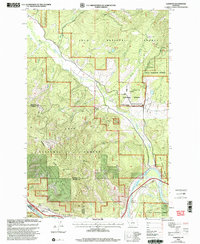 1999 Alberton2003 Print · USGSThe Mineral County mountainside meets the Clark Fork valley at the close of the twentieth century. Researchers can trace the legacy of forest management and early transport through the Ninemile Remount Depot, the CCC Campsite, and the winding Discovery Trail.
 - 1999 Map of Petty MountaIn, 2003 Print
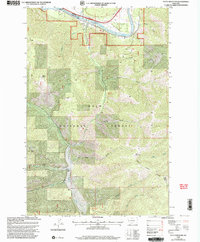 1999 Petty MountaIn2003 Print · USGSMissoula and Mineral Counties at the close of the century reveal a landscape of deep timber and mountain ranching. Researchers can trace historic extraction at the Coppersmith Mine, navigate the Clark Fork riverbank near Lothrop, or locate family sites like the Circle S Ranch.
End of results
Showing maps 1-2 of 2
Frequently asked questions
- What are the different types of historical maps available for Alberton?
- What is the oldest map of Alberton?
- Where can I purchase historical maps of Alberton for my home or office?
- Where can I download high-res historical maps of Alberton?
- Are there historical topographic maps available for Alberton?
- Is there historical aerial imagery available for Alberton?
- Where are historical maps of Alberton sourced from?