1960s Maps of Alberton, Montana
Explore 4 historic maps of Alberton from the 1960s. These maps offer a rare glimpse into what life looked like during the 1960s — showing old roads, neighborhoods, homes, and landmarks that have changed or disappeared over time.
Whether you're researching your family's past, planning a metal detecting trip, or studying how Alberton's landscape evolved across the 1960s, these high-resolution maps are a powerful tool for exploring the history of this region.
- Focus on a specific era: All maps on this page are from the 1960s, giving you a focused view of this time period.
- See what’s changed: Compare century-old streets, trails, and buildings to today's modern landscape using overlays and satellite layers.
- Research with precision: Use these maps for genealogy, historical research, land use analysis, or educational projects.
- View, download, or print: Maps are fully viewable online in high resolution, and can be downloaded or printed for your own records.
Start exploring Alberton's history through authentic maps from the 1960s. This is your window into the past.
Alberton, MT maps
(4)- 1960 Map of Wallace
 1960 Wallace1960 Print · USGSNorthwestern Montana and the Idaho panhandle are captured in the late fifties, showing the vast Flathead Indian Reservation and the mining districts of the Bitterroot Range. Researchers can trace the rail lines of the Northern Pacific or locate early sites like the Morning Mine and the National Bison Range.
 - 1960 Map of Hamilton
 1960 Hamilton1960 Print · USGSThe Bitterroot Valley and surrounding high country are captured here during the late fifties, showing the region's transition into a modern forest and rail corridor. Researchers can trace the path of the Northern Pacific through Missoula or locate landmarks like Fort Missoula and Lake Como.
 - 1964 Map of Hamilton
 1964 Hamilton1964 Print · USGSThe Bitterroot Valley and its surrounding peaks are captured in detail during the mid-1960s, showing the early infrastructure of the Northern Rockies. Genealogists and historians can trace family roots in Hamilton and Stevensville or follow the historic Lolo Trail and Nez Perce Trail.
 - 1964 Map of Petty Mountain, 1967 Print
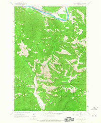 1964 Petty Mountain1967 Print · USGSMissoula and Mineral counties are defined by the Clark Fork river and dual rail lines during the mid-sixties. Trace the historical routes of the Northern Pacific through Alberton or locate the Copper Smith Mine tucked within the Lolo National Forest.
End of results
Showing maps 1-4 of 4
Frequently asked questions
- What are the different types of historical maps available for Alberton?
- What is the oldest map of Alberton?
- Where can I purchase historical maps of Alberton for my home or office?
- Where can I download high-res historical maps of Alberton?
- Are there historical topographic maps available for Alberton?
- Is there historical aerial imagery available for Alberton?
- Where are historical maps of Alberton sourced from?