1900s (20th Century) Maps of Quartz, Montana
Explore 5 historic maps of Quartz from the 1900s (20th Century). These maps offer a rare glimpse into what life looked like during the 1900s — showing old roads, neighborhoods, homes, and landmarks that have changed or disappeared over time.
Whether you're researching your family's past, planning a metal detecting trip, or studying how Quartz's landscape evolved across the 1900s, these high-resolution maps are a powerful tool for exploring the history of this region.
- Focus on a specific era: All maps on this page are from the 1900s, giving you a focused view of this time period.
- See what’s changed: Compare century-old streets, trails, and buildings to today's modern landscape using overlays and satellite layers.
- Research with precision: Use these maps for genealogy, historical research, land use analysis, or educational projects.
- View, download, or print: Maps are fully viewable online in high resolution, and can be downloaded or printed for your own records.
Start exploring Quartz's history through authentic maps from the 1900s. This is your window into the past.
Quartz, MT maps
(5)- 1956 Map of Wallace, 1966 Print
 1956 Wallace1966 Print · USGSWestern Montana and the Idaho panhandle meet in this mid-century survey of the Bitterroot and Cabinet Mountains. Genealogists and historians can trace the rail-and-river economy through the Northern Pacific line and settlements like Thompson Falls or St. Ignatius.3 unique versions available
 - 1960 Map of Wallace
 1960 Wallace1960 Print · USGSNorthwestern Montana and the Idaho panhandle are captured in the late fifties, showing the vast Flathead Indian Reservation and the mining districts of the Bitterroot Range. Researchers can trace the rail lines of the Northern Pacific or locate early sites like the Morning Mine and the National Bison Range.
 - 1960 Map of Superior, 1962 Print
 1960 Superior1962 Print · USGSThe Clark Fork valley in the early sixties was a rugged industrial corridor defined by the Northern Pacific and Milwaukee Road rail lines. Genealogists and historians can trace the foundations of Superior or locate remote mining sites like the Iron Mountain Mine and Old Mountain Mines.2 unique versions available
 - 1985 Map of Lozeau
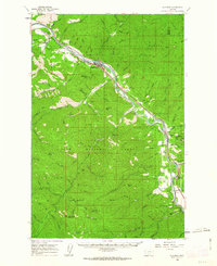
 1985 Lozeau1985 Print · USGSThe Clark Fork valley in the mid-eighties remains a rugged corridor of river-side settlements and vast timberland. Genealogists and researchers can trace the footprint of Lozeau and Westfall or locate the historic Mine and high points like Quartz Peak.
 - 1999 Map of Lozeau, 2003 Print
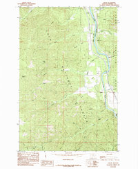
 1999 Lozeau2003 Print · USGSMineral County, Montana, is defined by the river and forest in the late nineties as this survey captures the corridor near the Clark Fork. Researchers can trace the small settlements of Lozeau and Westfall, locate a local Cem, or find historic Mine sites near Sunrise Creek.
End of results
Showing maps 1-5 of 5
Top cities near Quartz
Frequently asked questions
- What are the different types of historical maps available for Quartz?
- What is the oldest map of Quartz?
- Where can I purchase historical maps of Quartz for my home or office?
- Where can I download high-res historical maps of Quartz?
- Are there historical topographic maps available for Quartz?
- Is there historical aerial imagery available for Quartz?
- Where are historical maps of Quartz sourced from?