1980s Maps of Superior, Montana
Explore 2 historic maps of Superior from the 1980s. These maps offer a rare glimpse into what life looked like during the 1980s — showing old roads, neighborhoods, homes, and landmarks that have changed or disappeared over time.
Whether you're researching your family's past, planning a metal detecting trip, or studying how Superior's landscape evolved across the 1980s, these high-resolution maps are a powerful tool for exploring the history of this region.
- Focus on a specific era: All maps on this page are from the 1980s, giving you a focused view of this time period.
- See what’s changed: Compare century-old streets, trails, and buildings to today's modern landscape using overlays and satellite layers.
- Research with precision: Use these maps for genealogy, historical research, land use analysis, or educational projects.
- View, download, or print: Maps are fully viewable online in high resolution, and can be downloaded or printed for your own records.
Start exploring Superior's history through authentic maps from the 1980s. This is your window into the past.
Superior, MT maps
(2)- 1985 Map of Superior
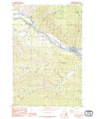 1985 Superior1985 Print · USGSMineral County in the mid-1980s reveals a mountain landscape centered on the Clark Fork river valley. Researchers can trace the layout of Superior and La Vista, or locate remote landmarks like Chimney Rock and Thompson Peak within the Lolo National Forest.
 - 1985 Map of Idaho Gulch
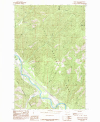 1985 Idaho Gulch1985 Print · USGSThe Clark Fork River corridor in the mid-1980s reveals a landscape of high timberland and river-bottom settlement. Trace the mountain topography from the Ninemile Divide down to Oliverville and the County Airport along the canyon floor.
End of results
Showing maps 1-2 of 2
Top cities near Superior
Top neighborhoods of Superior
Frequently asked questions
- What are the different types of historical maps available for Superior?
- What is the oldest map of Superior?
- Where can I purchase historical maps of Superior for my home or office?
- Where can I download high-res historical maps of Superior?
- Are there historical topographic maps available for Superior?
- Is there historical aerial imagery available for Superior?
- Where are historical maps of Superior sourced from?