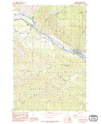
1985 Map of Superior
USGS Topo · Published 1985About this map
Superior serves as the focal point of this mid-1980s survey, situated along the northern banks of the Clark Fork river. The settlement is characterized by its proximity to vital infrastructure, including a substation and a trailer park on the eastern edge of town. To the northwest, the small community of La Vista sits near the confluence of Keystone Creek and the river, marking a distinct pocket of development against the massive backdrop of the Lolo National Forest.
Find a feature on this map
32 named features on this map. Tap any name to fly to it.
Don’t see what you’re looking for? This feature index may not catch every label — zoom into the map to look around manually.
Map Details
Editions of this 1985 Superior Map
This is the sole edition of this map. No revisions or reprints were ever made.
Other maps of this area

1918 · St Regis
USGS Topo · 1:125,000

1919 · St. Regis
USGS Topo · 1:125,000

1956 · St Regis
USGS Topo · 1:62,500

1956 · Wallace
USGS Topo · 1:250,000

1957 · Illinois Peak
USGS Topo · 1:62,500

1959 · Plains
USGS Topo · 1:62,500

1960 · Wallace
USGS Topo · 1:250,000

1960 · Superior
USGS Topo · 1:62,500
1985 · Quinns Hot Springs
USGS Topo · 1:24,000
1985 · Lozeau
USGS Topo · 1:24,000