1980s Maps of Huson, Montana
Explore 2 historic maps of Huson from the 1980s. These maps offer a rare glimpse into what life looked like during the 1980s — showing old roads, neighborhoods, homes, and landmarks that have changed or disappeared over time.
Whether you're researching your family's past, planning a metal detecting trip, or studying how Huson's landscape evolved across the 1980s, these high-resolution maps are a powerful tool for exploring the history of this region.
- Focus on a specific era: All maps on this page are from the 1980s, giving you a focused view of this time period.
- See what’s changed: Compare century-old streets, trails, and buildings to today's modern landscape using overlays and satellite layers.
- Research with precision: Use these maps for genealogy, historical research, land use analysis, or educational projects.
- View, download, or print: Maps are fully viewable online in high resolution, and can be downloaded or printed for your own records.
Start exploring Huson's history through authentic maps from the 1980s. This is your window into the past.
Huson, MT maps
(2)- 1984 Map of Huson
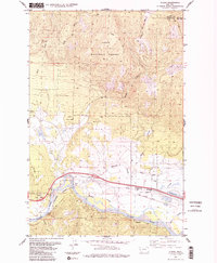 1984 Huson1984 Print · USGSHuson and the surrounding river valley are captured in the early 1980s as a hub for mountain transit and irrigation. Researchers can trace the historic Mullan Road, the winding Clark Fork, and localized landmarks like Frenchtown Pond and Edith Peak.2 unique versions available
 - 1988 Map of Huson
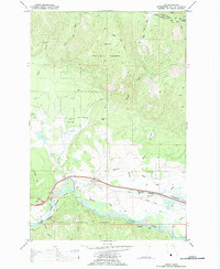 1988 Huson1988 Print · USGSIn the late eighties, the valley of the Clark Fork near Huson showcased a landscape of timber management and river-valley transport. Researchers can trace the path of the Burlington Northern and Mullan Road past sites like Frenchtown Pond and the Old Railroad Grade.
End of results
Showing maps 1-2 of 2
Top cities near Huson
Frequently asked questions
- What are the different types of historical maps available for Huson?
- What is the oldest map of Huson?
- Where can I purchase historical maps of Huson for my home or office?
- Where can I download high-res historical maps of Huson?
- Are there historical topographic maps available for Huson?
- Is there historical aerial imagery available for Huson?
- Where are historical maps of Huson sourced from?