1970s Maps of Petroleum County, Montana
Explore 3 historic maps of Petroleum County from the 1970s. These maps offer a rare glimpse into what life looked like during the 1970s — showing old roads, neighborhoods, homes, and landmarks that have changed or disappeared over time.
Whether you're researching your family's past, planning a metal detecting trip, or studying how Petroleum County's landscape evolved across the 1970s, these high-resolution maps are a powerful tool for exploring the history of this region.
- Focus on a specific era: All maps on this page are from the 1970s, giving you a focused view of this time period.
- See what’s changed: Compare century-old streets, trails, and buildings to today's modern landscape using overlays and satellite layers.
- Research with precision: Use these maps for genealogy, historical research, land use analysis, or educational projects.
- View, download, or print: Maps are fully viewable online in high resolution, and can be downloaded or printed for your own records.
Start exploring Petroleum County's history through authentic maps from the 1970s. This is your window into the past.
Petroleum County, MT maps
(3)- 1971 Map of Hanson Flat, 1975 Print
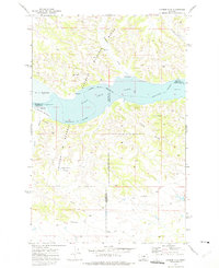 1971 Hanson Flat1975 Print · USGSThe Missouri and Musselshell Rivers converge here in the early 1970s within the sprawling protected lands of central Montana. Genealogists and historians can trace historic paths like the Old Musselshell Trail and locate the settlement of Fergus near Hanson Flat.
 - 1978 Map of Fort Peck Lake West
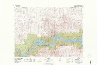 1978 Fort Peck Lake West1978 Print · USGSNorthern Montana plains and the Missouri River brakes are captured here in the late seventies. Researchers can trace remote outposts like Regina PO, the winding waters of Fort Peck Lake, and the solitary Coal Mine near the county line.2 unique versions available
 - 1979 Map of Melstone
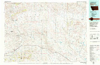 1979 Melstone1979 Print · USGSThe ranching and rail corridors of central Montana are preserved in this late 1970s survey. Genealogists and historians can trace the Milwaukee Road through settlements like Melstone, Ingomar, and Sumatra along the Musselshell River.
End of results
Showing maps 1-3 of 3
Top cities of Petroleum County
Frequently asked questions
- What are the different types of historical maps available for Petroleum County?
- What is the oldest map of Petroleum County?
- Where can I purchase historical maps of Petroleum County for my home or office?
- Where can I download high-res historical maps of Petroleum County?
- Are there historical topographic maps available for Petroleum County?
- Is there historical aerial imagery available for Petroleum County?
- Where are historical maps of Petroleum County sourced from?