1990s Maps of Petroleum County, Montana
Explore 2 historic maps of Petroleum County from the 1990s. These maps offer a rare glimpse into what life looked like during the 1990s — showing old roads, neighborhoods, homes, and landmarks that have changed or disappeared over time.
Whether you're researching your family's past, planning a metal detecting trip, or studying how Petroleum County's landscape evolved across the 1990s, these high-resolution maps are a powerful tool for exploring the history of this region.
- Focus on a specific era: All maps on this page are from the 1990s, giving you a focused view of this time period.
- See what’s changed: Compare century-old streets, trails, and buildings to today's modern landscape using overlays and satellite layers.
- Research with precision: Use these maps for genealogy, historical research, land use analysis, or educational projects.
- View, download, or print: Maps are fully viewable online in high resolution, and can be downloaded or printed for your own records.
Start exploring Petroleum County's history through authentic maps from the 1990s. This is your window into the past.
Petroleum County, MT maps
(2)- 1993 Map of Musselshell
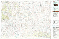 1993 Musselshell1993 Print · USGSCentral Montana's high plains and river valleys are shown in the early nineties, centered on the ranching and resource hubs of Winnett and Musselshell. Researchers can trace the Musselshell Ditch, locate the Melstone Oil Field, and explore the diverse wetlands of Lake Mason.
 - 1993 Map of Sand Springs
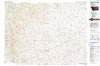 1993 Sand Springs1993 Print · USGSEastern Montana ranching and river country are shown here in the early nineties as the region balanced conservation and industry. You can trace family landmarks and drainages from Sand Springs to the Moss Dome Oil Field and the edges of Fort Peck Lake.
End of results
Showing maps 1-2 of 2
Top cities of Petroleum County
Frequently asked questions
- What are the different types of historical maps available for Petroleum County?
- What is the oldest map of Petroleum County?
- Where can I purchase historical maps of Petroleum County for my home or office?
- Where can I download high-res historical maps of Petroleum County?
- Are there historical topographic maps available for Petroleum County?
- Is there historical aerial imagery available for Petroleum County?
- Where are historical maps of Petroleum County sourced from?