1900s (20th Century) Maps of Otter, Montana
Explore 6 historic maps of Otter from the 1900s (20th Century). These maps offer a rare glimpse into what life looked like during the 1900s — showing old roads, neighborhoods, homes, and landmarks that have changed or disappeared over time.
Whether you're researching your family's past, planning a metal detecting trip, or studying how Otter's landscape evolved across the 1900s, these high-resolution maps are a powerful tool for exploring the history of this region.
- Focus on a specific era: All maps on this page are from the 1900s, giving you a focused view of this time period.
- See what’s changed: Compare century-old streets, trails, and buildings to today's modern landscape using overlays and satellite layers.
- Research with precision: Use these maps for genealogy, historical research, land use analysis, or educational projects.
- View, download, or print: Maps are fully viewable online in high resolution, and can be downloaded or printed for your own records.
Start exploring Otter's history through authentic maps from the 1900s. This is your window into the past.
Otter, MT maps
(6)- 1954 Map of Hardin, 1964 Print
 1954 Hardin1964 Print · USGSSoutheastern Montana is documented here during the mid-fifties, showing the vast tribal lands and historic battle sites before modern highway expansion. Researchers can trace the Chicago Burlington and Quincy rail line through Hardin or locate the Custer National Cemetery and Museum.2 unique versions available
 - 1957 Map of Hardin
 1957 Hardin1957 Print · USGSSoutheastern Montana in the mid-fifties reveals a landscape shaped by tribal lands and the historic Bighorn river valleys. Researchers can trace the Chicago Burlington and Quincy RR through Hardin and locate the National Cemetery and Custer Battlefield Monument.
 - 1958 Map of Hardin
 1958 Hardin1958 Print · USGSSoutheastern Montana in the mid-fifties presents a landscape defined by significant tribal lands and national monuments. Researchers can trace the geography of the Little Bighorn at Custer Battlefield National Monument and locate settlements like Lame Deer and Birney.
 - 1972 Map of Otter, 1976 Print
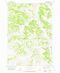 1972 Otter1976 Print · USGSPowder River County ranching and water management are on display in the early 1970s, centered on the community of Otter. Genealogists and historians can trace livestock water sources and remote landmarks like Lost Creek Reservoir and Happy Coulee Reservoir.2 unique versions available
 - 1980 Map of Birney
 1980 Birney1980 Print · USGSSoutheastern Montana enters a period of intensive energy development in the early 1980s as coal mines expand across the Big Horn County line. Researchers can trace the industrial footprints of the Spring Creek Mine and West Decker Mine or locate rural landmarks like the Birney Day School.
 - 1995 Map of Otter, 1998 Print
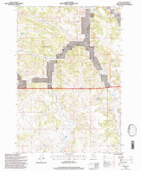 1995 Otter1998 Print · USGSPowder River County in the mid-1990s reveals a ranching and forestry landscape defined by its vital water sources. Researchers can trace land use through numerous named stock ponds like Happy Coulee Reservoir and Fletcher Reservoir, or locate landmarks such as Hoover Draw.
End of results
Showing maps 1-6 of 6
Frequently asked questions
- What are the different types of historical maps available for Otter?
- What is the oldest map of Otter?
- Where can I purchase historical maps of Otter for my home or office?
- Where can I download high-res historical maps of Otter?
- Are there historical topographic maps available for Otter?
- Is there historical aerial imagery available for Otter?
- Where are historical maps of Otter sourced from?