1960s Maps of Stacey, Montana
Explore 2 historic maps of Stacey from the 1960s. These maps offer a rare glimpse into what life looked like during the 1960s — showing old roads, neighborhoods, homes, and landmarks that have changed or disappeared over time.
Whether you're researching your family's past, planning a metal detecting trip, or studying how Stacey's landscape evolved across the 1960s, these high-resolution maps are a powerful tool for exploring the history of this region.
- Focus on a specific era: All maps on this page are from the 1960s, giving you a focused view of this time period.
- See what’s changed: Compare century-old streets, trails, and buildings to today's modern landscape using overlays and satellite layers.
- Research with precision: Use these maps for genealogy, historical research, land use analysis, or educational projects.
- View, download, or print: Maps are fully viewable online in high resolution, and can be downloaded or printed for your own records.
Start exploring Stacey's history through authentic maps from the 1960s. This is your window into the past.
Stacey, MT maps
(2)- 1965 Map of Ekalaka
 1965 Ekalaka1965 Print · USGSThe High Plains of Montana and Wyoming appear here in the mid-1950s, as a sprawling landscape of remote ranchlands and rural school districts. Researchers can trace the locations of many small landmarks like Mitchell School, Broadus, and the Humbolt Hills.
 - 1966 Map of Stacey, 1969 Print
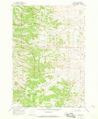 1966 Stacey1969 Print · USGSPowder River County is shown here in the 1960s, documenting a landscape of federal forest lands and small-scale ranching. Genealogists can trace the rural community near Stacey, while researchers can locate the South Stacey Sch and the Whitetail Ranger Sta.2 unique versions available
End of results
Showing maps 1-2 of 2
Frequently asked questions
- What are the different types of historical maps available for Stacey?
- What is the oldest map of Stacey?
- Where can I purchase historical maps of Stacey for my home or office?
- Where can I download high-res historical maps of Stacey?
- Are there historical topographic maps available for Stacey?
- Is there historical aerial imagery available for Stacey?
- Where are historical maps of Stacey sourced from?