1990s Maps of Ovando, Montana
Explore 2 historic maps of Ovando from the 1990s. These maps offer a rare glimpse into what life looked like during the 1990s — showing old roads, neighborhoods, homes, and landmarks that have changed or disappeared over time.
Whether you're researching your family's past, planning a metal detecting trip, or studying how Ovando's landscape evolved across the 1990s, these high-resolution maps are a powerful tool for exploring the history of this region.
- Focus on a specific era: All maps on this page are from the 1990s, giving you a focused view of this time period.
- See what’s changed: Compare century-old streets, trails, and buildings to today's modern landscape using overlays and satellite layers.
- Research with precision: Use these maps for genealogy, historical research, land use analysis, or educational projects.
- View, download, or print: Maps are fully viewable online in high resolution, and can be downloaded or printed for your own records.
Start exploring Ovando's history through authentic maps from the 1990s. This is your window into the past.
Ovando, MT maps
(2)- 1993 Map of Seeley Lake
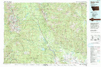 1993 Seeley Lake1993 Print · USGSThe Seeley Lake region in the early nineties is shown here as a landscape defined by its great wilderness boundaries and glacial waters. Researchers can trace the layout of Seeley Lake, the remote Danaher Guard Station, and historic routes like Montana 200 near Ovando.
 - 1999 Map of Ovando, 2003 Print
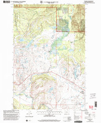 1999 Ovando2003 Print · USGSThe Blackfoot River valley in the 1990s remained a landscape of isolated ranching outposts and protected wilderness. Researchers can trace the layout of the Ovando townsite and locate historic rural properties like the Two Creek Ranch and Monture Hereford Ranch.
End of results
Showing maps 1-2 of 2
Top cities near Ovando
Frequently asked questions
- What are the different types of historical maps available for Ovando?
- What is the oldest map of Ovando?
- Where can I purchase historical maps of Ovando for my home or office?
- Where can I download high-res historical maps of Ovando?
- Are there historical topographic maps available for Ovando?
- Is there historical aerial imagery available for Ovando?
- Where are historical maps of Ovando sourced from?