1993 Map of Seeley Lake
USGS Topo · Published 1993About this map
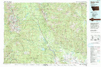
Seeley Lake serves as the central hub for this expansive 1993 study of the Clearwater and Blackfoot River valleys. The settlement pattern reflects the corridor of Montana 83, which threads through a chain of glacial waters including Salmon Lake, Placid Lake, Inez Lake, and Alva Lake. This network of lakes and rivers is framed by the massive protected lands of the Bob Marshall Wilderness and the Mission Mountains Wilderness.
Find a feature on this map
143 named features on this map. Tap any name to fly to it.
Don’t see what you’re looking for? This feature index may not catch every label — zoom into the map to look around manually.
Map Details
Editions of this 1993 Seeley Lake Map
This is the sole edition of this map. No revisions or reprints were ever made.
Other maps of this area

1889 · Helena
USGS Topo · 1:250,000

1893 · Helena
USGS Topo · 1:250,000

1899 · Helena
USGS Topo · 1:250,000

1902 · Ovando
USGS Topo · 1:125,000

1903 · Saypo
USGS Topo · 1:125,000

1903 · Coopers Lake
USGS Topo · 1:125,000

1903 · Bonner
USGS Topo · 1:125,000

1903 · Helena
USGS Topo · 1:250,000

1905 · Ovando
USGS Topo · 1:125,000

1912 · Missoula
USGS Topo · 1:125,000