1960s Maps of Ashland District, Montana
Explore 4 historic maps of Ashland District from the 1960s. These maps offer a rare glimpse into what life looked like during the 1960s — showing old roads, neighborhoods, homes, and landmarks that have changed or disappeared over time.
Whether you're researching your family's past, planning a metal detecting trip, or studying how Ashland District's landscape evolved across the 1960s, these high-resolution maps are a powerful tool for exploring the history of this region.
- Focus on a specific era: All maps on this page are from the 1960s, giving you a focused view of this time period.
- See what’s changed: Compare century-old streets, trails, and buildings to today's modern landscape using overlays and satellite layers.
- Research with precision: Use these maps for genealogy, historical research, land use analysis, or educational projects.
- View, download, or print: Maps are fully viewable online in high resolution, and can be downloaded or printed for your own records.
Start exploring Ashland District's history through authentic maps from the 1960s. This is your window into the past.
Ashland District, MT maps
(4)- 1966 Map of Ashland, 1969 Print
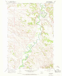 1966 Ashland1969 Print · USGSThe Tongue River valley in the mid-1960s reveals the intersection of reservation life and forest management near the Rosebud County line. Genealogists and local historians can trace the grounds of the St Labre Mission, the streets of Ashland, and the Ranger Sta in the national forest.3 unique versions available
 - 1966 Map of Birney Day School, 1969 Print
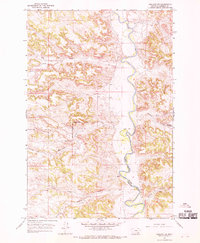
 1966 Birney Day School1969 Print · USGSThe Tongue River valley in the mid-1960s highlights the interface between the Northern Cheyenne Reservation and national forest lands. Genealogists and local historians can locate the Birney Day School, a local Cem, and rural landmarks like Nance Landing Field.3 unique versions available
 - 1966 Map of Ashland NE, 1970 Print
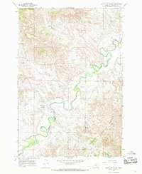
 1966 Ashland NE1970 Print · USGSRosebud County ranchlands and tribal territories are captured here in the mid-sixties as the Tongue River winds through the high plains. Genealogists and historians can trace the Northern Cheyenne Indian Reservation Boundary and locate family landmarks like Wakefield Spring or Stebbins Creek.2 unique versions available
 - 1966 Map of Green Creek, 1970 Print
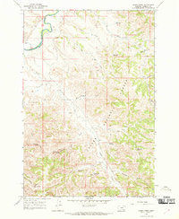 1966 Green Creek1970 Print · USGSSoutheast Montana ranching and reservation lands are captured here in the mid-1960s, showing the intersection of the Tongue River and forest highlands. Researchers can trace the Northern Cheyenne Indian Reservation Boundary and find numerous remote water improvements like O'Dell Windmill and Pittman Spring.2 unique versions available
End of results
Showing maps 1-4 of 4
Top neighborhoods of Ashland District
Frequently asked questions
- What are the different types of historical maps available for Ashland District?
- What is the oldest map of Ashland District?
- Where can I purchase historical maps of Ashland District for my home or office?
- Where can I download high-res historical maps of Ashland District?
- Are there historical topographic maps available for Ashland District?
- Is there historical aerial imagery available for Ashland District?
- Where are historical maps of Ashland District sourced from?