
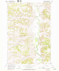
1966 Map of Ashland NE
USGS Topo · Published 1970About this map
The Northern Cheyenne Indian Reservation Boundary bisects this landscape, delineating a territory where complex terrain meets the essential water of the Tongue River. Surveyed in the mid-1960s, the map reveals a remote ranching and reservation environment defined by deep drainage networks and seasonal water sources. The sinuous path of the river dominates the eastern half, fed by numerous tributaries including Bringoff Creek and Stebbins Creek.
Find a feature on this map
16 named features on this map. Tap any name to fly to it.
Don’t see what you’re looking for? This feature index may not catch every label — zoom into the map to look around manually.
Map Details
Editions of this 1966 Ashland NE Map
2 editions found
Other maps of this area

1954 · Hardin
USGS Topo · 1:250,000

1957 · Hardin
USGS Topo · 1:250,000

1958 · Hardin
USGS Topo · 1:250,000

1958 · Garfield Peak
USGS Topo · 1:24,000

1958 · Hollowwood Creek
USGS Topo · 1:24,000

1966 · Ashland
USGS Topo · 1:24,000

1966 · Cook Creek Reservoir
USGS Topo · 1:24,000

1966 · Willow Crossing
USGS Topo · 1:24,000

1971 · Hammond Draw
USGS Topo · 1:24,000
1971 · Hammond Draw SW
USGS Topo · 1:24,000