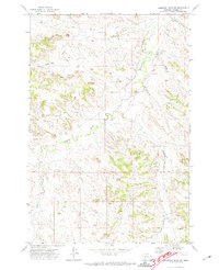
1971 Map of Hammond Draw SW
USGS Topo · Published 1974About this map
Rosebud Creek winds through this sparsely settled corner of Rosebud County, providing the primary drainage for a landscape shaped by deep coulees and seasonal watercourses. Surveyed in the early 1970s, the map reveals a pastoral territory where land use is concentrated along the creek bottoms and defined by the Montana Base Line. Local history is anchored by the presence of Bear Cem and Brown Cem, which stand as small but significant markers of early ranching families and homesteaders in the area. Evidence of resource exploration and local industry appears in the form of a Gravel Pit and scattered Drill Hole locations. The terrain is further characterized by the confluence of numerous smaller tributaries such as Greenleaf Creek, Miller Creek, and Cow Creek, illustrating the complex drainage patterns essential to Montana's high plains ranching economy.
Find a feature on this map
17 named features on this map. Tap any name to fly to it.
Don’t see what you’re looking for? This feature index may not catch every label — zoom into the map to look around manually.
Map Details
Editions of this 1971 Hammond Draw SW Map
This is the sole edition of this map. No revisions or reprints were ever made.
Other maps of this area

1954 · Hardin
USGS Topo · 1:250,000

1957 · Hardin
USGS Topo · 1:250,000

1958 · Hardin
USGS Topo · 1:250,000

1958 · Garfield Peak
USGS Topo · 1:24,000

1958 · Badger Peak
USGS Topo · 1:24,000

1966 · Ashland NE
USGS Topo · 1:24,000

1971 · Colstrip SE
USGS Topo · 1:24,000

1971 · Hammond Draw NW
USGS Topo · 1:24,000

1971 · Colstrip East
USGS Topo · 1:24,000

1971 · Hammond Draw
USGS Topo · 1:24,000