
1971 Map of Colstrip SE
USGS Topo · Published 1974About this map
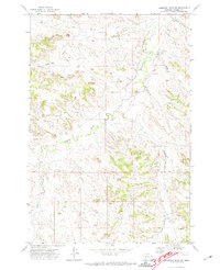
Industrial activity defines the northern landscape of this Rosebud County survey, dominated by a massive Strip Mine and its accompanying infrastructure. The Burlington Northern railroad winds through the terrain, serving the extraction sites and connecting the remote coulees to wider markets. The transition from industrial earthmoving to the traditional ranching landscape is evident as the map moves south toward Rosebud Creek. In this rural expanse, the Lee Cem stands as a quiet marker of local genealogy near the winding drainage of Lee Coulee. The terrain is deeply etched by a network of seasonal watercourses including Miller Coulee and Hay Coulee, illustrating the complex drainage patterns that dictate movement and settlement in this part of Montana.
Find a feature on this map
15 named features on this map. Tap any name to fly to it.
Don’t see what you’re looking for? This feature index may not catch every label — zoom into the map to look around manually.
Map Details
Editions of this 1971 Colstrip SE Map
This is the sole edition of this map. No revisions or reprints were ever made.
Other maps of this area

1954 · Hardin
USGS Topo · 1:250,000

1957 · Hardin
USGS Topo · 1:250,000

1958 · Hardin
USGS Topo · 1:250,000

1958 · Garfield Peak
USGS Topo · 1:24,000

1958 · Jimtown
USGS Topo · 1:24,000

1958 · Badger Peak
USGS Topo · 1:24,000

1971 · Colstrip SW
USGS Topo · 1:24,000

1971 · Hammond Draw NW
USGS Topo · 1:24,000

1971 · Colstrip East
USGS Topo · 1:24,000
1971 · Hammond Draw SW
USGS Topo · 1:24,000