
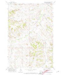
1971 Map of Hammond Draw NW
USGS Topo · Published 1974About this map
Rosebud Creek flows through this high plains drainage system in Rosebud County, Montana, carving a distinct valley through the rolling topography of the early 1970s. The landscape is defined by its complex network of named ephemeral and perennial waterways, including Sprague Creek and Pony Creek, which have shaped the local ranching and grazing terrain over decades. Human activity on the land is marked by small-scale resource extraction and infrastructure, such as the Gravel Pit near the northern border and various well sites scattered across the sections. The intricate branching of Snider Creek and West Snider Creek illustrates the importance of water management in this arid stretch of the Treasure State, while features like Sand Coulee point to the geological character of the watershed during this period of rural development.
Find a feature on this map
11 named features on this map. Tap any name to fly to it.
Don’t see what you’re looking for? This feature index may not catch every label — zoom into the map to look around manually.
Map Details
Editions of this 1971 Hammond Draw NW Map
This is the sole edition of this map. No revisions or reprints were ever made.
Other maps of this area

1954 · Hardin
USGS Topo · 1:250,000

1954 · Forsyth
USGS Topo · 1:250,000

1957 · Hardin
USGS Topo · 1:250,000

1957 · Forsyth
USGS Topo · 1:250,000

1958 · Forsyth
USGS Topo · 1:250,000

1958 · Hardin
USGS Topo · 1:250,000

1971 · Colstrip SE
USGS Topo · 1:24,000

1971 · Colstrip East
USGS Topo · 1:24,000

1971 · Hammond Draw
USGS Topo · 1:24,000
1971 · Hammond Draw SW
USGS Topo · 1:24,000