
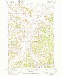
1958 Map of Jimtown
USGS Topo · Published 1960About this map
Jimtown and the surrounding ranchlands sit at the boundary of the Northern Cheyenne Indian Reservation, where the landscape is defined by the winding course of Rosebud Creek. Published in 1960 from surveys conducted in the late 1950s, this sheet details the rural infrastructure of the region, including the McKay Ranch and Bailey Ranch. The presence of a Sawmill and a small Airstrip (Private) near Little Cottonwood Creek suggests a specialized local economy centered on timber and remote transport. A lone Cem and the settlement at Blackstone provide specific points of interest for genealogists tracing family roots in this corner of the Rosebud and Big Horn County line. The terrain transitions from the broad flats of Rye Grass Creek to more complex breaks such as Yellow Fox Gulch and Davidson Hill.
Find a feature on this map
25 named features on this map. Tap any name to fly to it.
Don’t see what you’re looking for? This feature index may not catch every label — zoom into the map to look around manually.
Map Details
Editions of this 1958 Jimtown Map
2 editions found
Other maps of this area

1954 · Hardin
USGS Topo · 1:250,000

1957 · Hardin
USGS Topo · 1:250,000

1958 · Hardin
USGS Topo · 1:250,000

1958 · Painted Hill
USGS Topo · 1:24,000

1958 · Black Spring
USGS Topo · 1:24,000

1958 · Fisher Butte
USGS Topo · 1:24,000

1958 · Lame Deer
USGS Topo · 1:24,000

1958 · Badger Peak
USGS Topo · 1:24,000

1971 · Colstrip SW
USGS Topo · 1:24,000

1971 · Colstrip SE
USGS Topo · 1:24,000