
1958 Map of Painted Hill
USGS Topo · Published 1960About this map
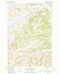
Rosebud Creek and its complex network of tributaries define this landscape in Big Horn County during the late 1950s. The map captures a high-plateau environment marked by intermittent drainage and significant topographical markers like Painted Hill and Shavedhead. Water management in this arid stretch is evident at Two Moon Reservoir, which feeds into Two Moon Creek. The area is dissected by numerous named drainages including Killnight Creek, Little Chief Creek, and the West Fork Muddy Creek, showing the natural erosion patterns of the northern plains. Human presence is indicated primarily through a network of trails and jeep trails that navigate between landmarks such as Indian Coulee and David Gulch, reflecting a period when motorized access was beginning to expand across traditional ranching or grazing lands.
Find a feature on this map
24 named features on this map. Tap any name to fly to it.
Don’t see what you’re looking for? This feature index may not catch every label — zoom into the map to look around manually.
Map Details
Editions of this 1958 Painted Hill Map
2 editions found
Other maps of this area

1954 · Hardin
USGS Topo · 1:250,000

1957 · Hardin
USGS Topo · 1:250,000

1958 · Hardin
USGS Topo · 1:250,000

1958 · Chalky Point
USGS Topo · 1:24,000

1958 · Bull Creek Lookout
USGS Topo · 1:24,000

1958 · Jimtown
USGS Topo · 1:24,000

1958 · Black Spring
USGS Topo · 1:24,000

1958 · Busby
USGS Topo · 1:24,000

1958 · Birdseye Spring
USGS Topo · 1:24,000

1958 · Lame Deer
USGS Topo · 1:24,000