
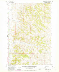
1958 Map of Birdseye Spring
USGS Topo · Published 1960About this map
Rosebud Creek and its complex network of seasonal drainages define this stretch of Montana ranch land in the late 1950s. The landscape is characterized by deeply eroded coulees and breaks, where the water table is accessible through features like Birdseye Spring. This 1:24,000 scale survey, conducted as part of the Department of the Interior program for the development of the Missouri River Basin, reveals a territory managed for grazing and transit long before significant modernization. Watercourses such as East Thompson Creek, Skunk Creek, and Eagle Creek carve the topography, while established paths like Trail Creek and various jeep trails suggest the movement of livestock and people through the Big Horn backcountry. The map provides an essential reference for understanding the rural hydrology and land use patterns of the era.
Find a feature on this map
13 named features on this map. Tap any name to fly to it.
Don’t see what you’re looking for? This feature index may not catch every label — zoom into the map to look around manually.
Map Details
Editions of this 1958 Birdseye Spring Map
2 editions found
Other maps of this area

1894 · Rosebud
USGS Topo · 1:125,000

1901 · Rosebud
USGS Topo · 1:125,000

1954 · Hardin
USGS Topo · 1:250,000

1957 · Hardin
USGS Topo · 1:250,000

1958 · Hardin
USGS Topo · 1:250,000

1958 · Painted Hill
USGS Topo · 1:24,000

1958 · Bull Creek Lookout
USGS Topo · 1:24,000

1958 · Busby
USGS Topo · 1:24,000

1967 · Kirby
USGS Topo · 1:24,000
1967 · Taintor Desert
USGS Topo · 1:24,000