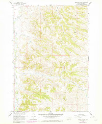
1958 Map of Birdseye Spring
USGS Topo · Published 1978About this map
Rosebud Creek and its complex network of tributaries carve through the Northern Cheyenne Indian Reservation, revealing a landscape defined by water and topography. This area, updated with aerial data through the late 1970s, shows a series of named drainages like Skunk Creek, Trail Creek, and East Thompson Creek that drain the high ridges of Big Horn County. The presence of Birdseye Spring and various unnamed springs suggests the critical importance of reliable water sources in this dry Montana environment. While few permanent structures are noted, the inclusion of a Jeep Trial in the northeast and numerous smaller paths indicate how the terrain was navigated for ranching or resource management. The map effectively captures the interface between the valley floor along the Rosebud Creek and the upland draws of South Fork Dry Creek and Eagle Creek.
Find a feature on this map
13 named features on this map. Tap any name to fly to it.
Don’t see what you’re looking for? This feature index may not catch every label — zoom into the map to look around manually.
Map Details
Editions of this 1958 Birdseye Spring Map
2 editions found
Other maps of this area

1894 · Rosebud
USGS Topo · 1:125,000

1901 · Rosebud
USGS Topo · 1:125,000

1954 · Hardin
USGS Topo · 1:250,000

1957 · Hardin
USGS Topo · 1:250,000

1958 · Hardin
USGS Topo · 1:250,000

1958 · Painted Hill
USGS Topo · 1:24,000

1958 · Bull Creek Lookout
USGS Topo · 1:24,000

1958 · Busby
USGS Topo · 1:24,000

1958 · Birdseye Spring
USGS Topo · 1:24,000

1967 · Kirby
USGS Topo · 1:24,000