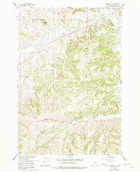
1958 Map of Painted Hill
USGS Topo · Published 1978About this map
Painted Hill rises above a complex drainage system within the Northern Cheyenne Indian Reservation during the mid-twentieth century. The landscape is defined by its watercourses, featuring prominent streams like Rosebud Creek and the West Fork Muddy Creek. This 1958 survey, updated with 1976 aerial revisions, captures a network of trails and jeep trails that navigate the varied terrain between David Creek and Horse Creek.
Find a feature on this map
22 named features on this map. Tap any name to fly to it.
Don’t see what you’re looking for? This feature index may not catch every label — zoom into the map to look around manually.
Map Details
Editions of this 1958 Painted Hill Map
2 editions found
Other maps of this area

1954 · Hardin
USGS Topo · 1:250,000

1957 · Hardin
USGS Topo · 1:250,000

1958 · Hardin
USGS Topo · 1:250,000

1958 · Chalky Point
USGS Topo · 1:24,000

1958 · Painted Hill
USGS Topo · 1:24,000

1958 · Bull Creek Lookout
USGS Topo · 1:24,000

1958 · Jimtown
USGS Topo · 1:24,000

1958 · Black Spring
USGS Topo · 1:24,000

1958 · Busby
USGS Topo · 1:24,000

1958 · Birdseye Spring
USGS Topo · 1:24,000