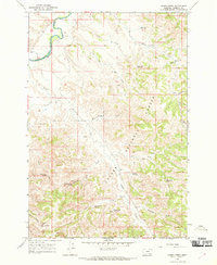
1966 Map of Green Creek
USGS Topo · Published 1970About this map
The Northern Cheyenne Indian Reservation Boundary defines the northwestern corner of this landscape, where the Tongue River meanders through a narrow valley before entering the broader canyon country. Much of the eastern and southern terrain lies within the Custer National Forest, a region characterized by deep draws and high ridges. The map reveals a sophisticated network of water management essential for ranching in this arid environment, featuring numerous livestock improvements such as the O'Dell Windmill and the Section 16 Windmill.
Find a feature on this map
32 named features on this map. Tap any name to fly to it.
Don’t see what you’re looking for? This feature index may not catch every label — zoom into the map to look around manually.
Map Details
Editions of this 1966 Green Creek Map
2 editions found
Other maps of this area

1954 · Hardin
USGS Topo · 1:250,000

1957 · Hardin
USGS Topo · 1:250,000

1958 · Hardin
USGS Topo · 1:250,000

1958 · Hollowwood Creek
USGS Topo · 1:24,000

1966 · Browns Mountain
USGS Topo · 1:24,000

1966 · Ashland
USGS Topo · 1:24,000

1966 · Birney Day School
USGS Topo · 1:24,000

1966 · Poker Jim Butte
USGS Topo · 1:24,000

1966 · Fort Howes
USGS Topo · 1:24,000

1966 · King Mountain
USGS Topo · 1:24,000