1900s (20th Century) Maps of Talc, Montana
Explore 8 historic maps of Talc from the 1900s (20th Century). These maps offer a rare glimpse into what life looked like during the 1900s — showing old roads, neighborhoods, homes, and landmarks that have changed or disappeared over time.
Whether you're researching your family's past, planning a metal detecting trip, or studying how Talc's landscape evolved across the 1900s, these high-resolution maps are a powerful tool for exploring the history of this region.
- Focus on a specific era: All maps on this page are from the 1900s, giving you a focused view of this time period.
- See what’s changed: Compare century-old streets, trails, and buildings to today's modern landscape using overlays and satellite layers.
- Research with precision: Use these maps for genealogy, historical research, land use analysis, or educational projects.
- View, download, or print: Maps are fully viewable online in high resolution, and can be downloaded or printed for your own records.
Start exploring Talc's history through authentic maps from the 1900s. This is your window into the past.
Talc, MT maps
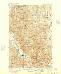
(8)- 1937 Map of Thompson Falls
 1937 Thompson Falls1937 Print · USGSThe Clark Fork river valley and the high Cabinet Mountains are documented here in the mid-1930s. Genealogists and researchers can trace the early railroad communities of Thompson Falls and Belknap or locate the Silver Butte Fisher Sch and Bend Ranger Sta.2 unique versions available
 - 1937 Map of Thompson Falls, 1949 Print
 1937 Thompson Falls1949 Print · USGSThe Clark Fork valley in the 1930s was a vital corridor defined by the Northern Pacific Line and riverside settlements. Researchers can trace early infrastructure and mountain life through the locations of the Silver Butte Fisher Sch, the Bend Ranger Sta, and the ferry at Eddy.
 - 1956 Map of Wallace, 1966 Print
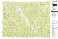
 1956 Wallace1966 Print · USGSWestern Montana and the Idaho panhandle meet in this mid-century survey of the Bitterroot and Cabinet Mountains. Genealogists and historians can trace the rail-and-river economy through the Northern Pacific line and settlements like Thompson Falls or St. Ignatius.3 unique versions available
 - 1957 Map of Thompson Falls, 1959 Print
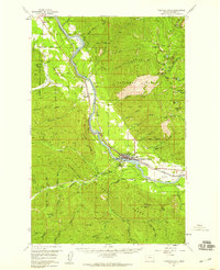 1957 Thompson Falls1959 Print · USGSThompson Falls and the Clark Fork valley are documented here in the late fifties, just as the proposed Noxon Rapids Reservoir was set to alter the riverbanks. Researchers can trace the Northern Pacific rail line, locate the Lucky Luke Mine, and find local landmarks like VFW Cem.3 unique versions available
 - 1960 Map of Wallace
 1960 Wallace1960 Print · USGSNorthwestern Montana and the Idaho panhandle are captured in the late fifties, showing the vast Flathead Indian Reservation and the mining districts of the Bitterroot Range. Researchers can trace the rail lines of the Northern Pacific or locate early sites like the Morning Mine and the National Bison Range.
 - 1988 Map of Belknap
 1988 Belknap1988 Print · USGSThe Clark Fork valley in the late eighties reveals a landscape where mountain wilderness meets reservoir infrastructure. Family historians and researchers can trace the small settlement of Belknap, locate a local Cem, or identify the Lucky Luke Mine Prospects.
 - 1992 Map of Thompson Falls, 1993 Print
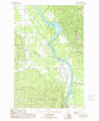
 1992 Thompson Falls1993 Print · USGSNorthwest Montana in the early nineties is defined here by the winding Clark Fork and its major impoundments. Researchers can trace the river-valley settlements of Noxon, Trout Creek, and Thompson Falls or locate mining sites like the Copper King Mine.
 - 1999 Map of Belknap, 2003 Print
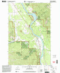 1999 Belknap2003 Print · USGSSanders County in the late twentieth century remains defined by the winding Clark Fork and its federal forest lands. Local historians can trace the foundations of the area at White Pine Station (Site), locate the Lucky Luke Mine, or find early cemetery sites like Cem.
End of results
Showing maps 1-8 of 8
Top cities near Talc
Frequently asked questions
- What are the different types of historical maps available for Talc?
- What is the oldest map of Talc?
- Where can I purchase historical maps of Talc for my home or office?
- Where can I download high-res historical maps of Talc?
- Are there historical topographic maps available for Talc?
- Is there historical aerial imagery available for Talc?
- Where are historical maps of Talc sourced from?