1960s Maps of Buxton, Butte
Explore 3 historic maps of Buxton from the 1960s. These maps offer a rare glimpse into what life looked like during the 1960s — showing old roads, neighborhoods, homes, and landmarks that have changed or disappeared over time.
Whether you're researching your family's past, planning a metal detecting trip, or studying how Buxton's landscape evolved across the 1960s, these high-resolution maps are a powerful tool for exploring the history of this region.
- Focus on a specific era: All maps on this page are from the 1960s, giving you a focused view of this time period.
- See what’s changed: Compare century-old streets, trails, and buildings to today's modern landscape using overlays and satellite layers.
- Research with precision: Use these maps for genealogy, historical research, land use analysis, or educational projects.
- View, download, or print: Maps are fully viewable online in high resolution, and can be downloaded or printed for your own records.
Start exploring Buxton's history through authentic maps from the 1960s. This is your window into the past.
Buxton, Butte maps
(3)- 1961 Map of Butte South, 1964 Print
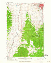 1961 Butte South1964 Print · USGSThe industrial outskirts of Butte meet the high timber of the Continental Divide in the early 1960s. Genealogists can locate several major cemeteries like Holy Cross Cem and Mountain View Cem, while researchers can trace rail lines to Feeley and the old Moose Town (Site).2 unique versions available
 - 1962 Map of Dillon
 1962 Dillon1962 Print · USGSSouthwest Montana in the early sixties is defined by its high mountain ranges and the winding rivers that carved its settlement patterns. Trace the rail routes of the Union Pacific through Dillon or locate mining activity near Butte and Argenta.
 - 1965 Map of Dillon
 1965 Dillon1965 Print · USGSSouthwest Montana in the mid-1960s is defined by its rugged river valleys and high mountain passes along the Continental Divide. Researchers can trace the path of the Union Pacific through Dillon and Armstead, or locate early mining activity near Melrose and Wise River.
End of results
Showing maps 1-3 of 3
Top cities near Buxton
Frequently asked questions
- What are the different types of historical maps available for Buxton?
- What is the oldest map of Buxton?
- Where can I purchase historical maps of Buxton for my home or office?
- Where can I download high-res historical maps of Buxton?
- Are there historical topographic maps available for Buxton?
- Is there historical aerial imagery available for Buxton?
- Where are historical maps of Buxton sourced from?