1960s Maps of Koyl, Montana
Explore 2 historic maps of Koyl from the 1960s. These maps offer a rare glimpse into what life looked like during the 1960s — showing old roads, neighborhoods, homes, and landmarks that have changed or disappeared over time.
Whether you're researching your family's past, planning a metal detecting trip, or studying how Koyl's landscape evolved across the 1960s, these high-resolution maps are a powerful tool for exploring the history of this region.
- Focus on a specific era: All maps on this page are from the 1960s, giving you a focused view of this time period.
- See what’s changed: Compare century-old streets, trails, and buildings to today's modern landscape using overlays and satellite layers.
- Research with precision: Use these maps for genealogy, historical research, land use analysis, or educational projects.
- View, download, or print: Maps are fully viewable online in high resolution, and can be downloaded or printed for your own records.
Start exploring Koyl's history through authentic maps from the 1960s. This is your window into the past.
Koyl, MT maps
(2)- 1960 Map of Bynum, 1962 Print
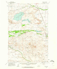 1960 Bynum1962 Print · USGSThe Bynum area during the early 1960s was a hub of irrigation and rail-side ranching. Genealogists and historians can trace family holdings like Perkins Ranch, find the Tetonview Sch, and locate the Miller Colony north of Koyl.2 unique versions available
 - 1962 Map of Choteau
 1962 Choteau1962 Print · USGSThe Rocky Mountain Front meets the western plains in the early 1960s, showing a landscape defined by the Continental Divide. Genealogists and researchers can trace the tracks of the Great Northern and find settlements like Choteau, Augusta, and Bynum.
End of results
Showing maps 1-2 of 2
Top cities near Koyl
Frequently asked questions
- What are the different types of historical maps available for Koyl?
- What is the oldest map of Koyl?
- Where can I purchase historical maps of Koyl for my home or office?
- Where can I download high-res historical maps of Koyl?
- Are there historical topographic maps available for Koyl?
- Is there historical aerial imagery available for Koyl?
- Where are historical maps of Koyl sourced from?