1980s Maps of Antelope County, Nebraska
Explore 5 historic maps of Antelope County from the 1980s. These maps offer a rare glimpse into what life looked like during the 1980s — showing old roads, neighborhoods, homes, and landmarks that have changed or disappeared over time.
Whether you're researching your family's past, planning a metal detecting trip, or studying how Antelope County's landscape evolved across the 1980s, these high-resolution maps are a powerful tool for exploring the history of this region.
- Focus on a specific era: All maps on this page are from the 1980s, giving you a focused view of this time period.
- See what’s changed: Compare century-old streets, trails, and buildings to today's modern landscape using overlays and satellite layers.
- Research with precision: Use these maps for genealogy, historical research, land use analysis, or educational projects.
- View, download, or print: Maps are fully viewable online in high resolution, and can be downloaded or printed for your own records.
Start exploring Antelope County's history through authentic maps from the 1980s. This is your window into the past.
Antelope County, NE maps
(5)- 1985 Map of O'Neill
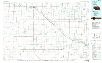 1985 O'Neill1985 Print · USGSThe Elkhorn River valley and its surrounding plains are captured in the mid-1980s, showing a landscape defined by rail lines and ranching hubs. Genealogists and local historians can trace the rail networks of the Chicago and North Western and find smaller locales like Knievels Corner, Amelia, and Venus.2 unique versions available
 - 1985 Map of Ord
 1985 Ord1985 Print · USGSCentral Nebraska's river valleys were defined by the rail and irrigation networks of the mid-1980s. Genealogists can trace family roots in towns like Ord and Albion or locate landmarks like Pilot Knob and the Pibel Lake State Recreation Area.2 unique versions available
 - 1985 Map of Stanton
 1985 Stanton1985 Print · USGSNortheast Nebraska in the mid-eighties shows a landscape of river-valley agriculture and evolving rail networks. Genealogists can trace family footprints through Stanton and Madison, or locate historical markers like the Old Indian Treaty Boundary and Saint Bernard.2 unique versions available
 - 1985 Map of Norfolk, 1986 Print
 1985 Norfolk1986 Print · USGSNortheast Nebraska in the mid-eighties shows a landscape shaped by the Elkhorn River and established rail corridors. Trace the growth of towns like Norfolk and Wayne, locating institutional landmarks such as Wayne State College and Norfolk Regional Center.2 unique versions available
 - 1989 Map of O'Neill
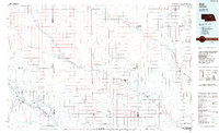
 1989 O'Neill1989 Print · USGSThe Nebraska-South Dakota borderlands are captured here in the late eighties, documenting the ranching and rail infrastructure of the High Plains. Genealogists and collectors can trace historic prairie towns like Monowi, Pishelville, and Santee along the Niobrara River.
End of results
Showing maps 1-5 of 5
Top cities of Antelope County
- Neligh historical maps
- Elgin historical maps
- Clearwater historical maps
- Orchard historical maps
- Oakdale historical maps
- Brunswick historical maps
See more
Frequently asked questions
- What are the different types of historical maps available for Antelope County?
- What is the oldest map of Antelope County?
- Where can I purchase historical maps of Antelope County for my home or office?
- Where can I download high-res historical maps of Antelope County?
- Are there historical topographic maps available for Antelope County?
- Is there historical aerial imagery available for Antelope County?
- Where are historical maps of Antelope County sourced from?