1980s Maps of Box Butte County, Nebraska
Explore 14 historic maps of Box Butte County from the 1980s. These maps offer a rare glimpse into what life looked like during the 1980s — showing old roads, neighborhoods, homes, and landmarks that have changed or disappeared over time.
Whether you're researching your family's past, planning a metal detecting trip, or studying how Box Butte County's landscape evolved across the 1980s, these high-resolution maps are a powerful tool for exploring the history of this region.
- Focus on a specific era: All maps on this page are from the 1980s, giving you a focused view of this time period.
- See what’s changed: Compare century-old streets, trails, and buildings to today's modern landscape using overlays and satellite layers.
- Research with precision: Use these maps for genealogy, historical research, land use analysis, or educational projects.
- View, download, or print: Maps are fully viewable online in high resolution, and can be downloaded or printed for your own records.
Start exploring Box Butte County's history through authentic maps from the 1980s. This is your window into the past.
Box Butte County, NE maps
(14)- 1983 Map of Marsland SE, 1984 Print
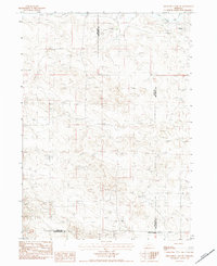
 1983 Marsland SE1984 Print · USGSBox Butte County in the early eighties shows a high plains landscape organized by the grid of the Panhandle. Genealogists and local researchers can locate Lawn Cem or trace the watercourses of North Branch Point of Rocks Creek.
 - 1983 Map of Marsland, 1984 Print
 1983 Marsland1984 Print · USGSMarsland and the high plains of the Nebraska Panhandle are captured here in the early eighties. Genealogists and local historians can trace the Marsland Cem and the path of the Burlington Northern railroad along the Niobrara River.
 - 1983 Map of Kilpatrick Lake, 1984 Print
 1983 Kilpatrick Lake1984 Print · USGSBox Butte and Morrill counties appear in the early eighties as a landscape of remote ranches and vital water management. Genealogists and local historians can locate the Snake Creek Cemetery, School Number 22, and the sprawling Snake Creek Ranch.
 - 1983 Map of Kilpatrick Lake NW, 1984 Print
 1983 Kilpatrick Lake NW1984 Print · USGSThe high plains on the Sioux and Box Butte county line appear here in the early 1980s as a land of expansive cattle operations. Genealogists and local historians can trace legacy family holdings such as the Hood Ranch, Locker Ranch, and I B Henderson Ranch along the winding Snake Creek.
 - 1983 Map of Marsland SW, 1984 Print
 1983 Marsland SW1984 Print · USGSWestern Nebraska's high plains transition into rugged ranchland in the early 1980s. Local history researchers can locate family sites like the Bohemian Pioneer Cem and trace the survey line of Sioux Co Box Butte Co.
 - 1983 Map of Marsland NW, 1984 Print
 1983 Marsland NW1984 Print · USGSNorthwest Nebraska in the early 1980s shows a landscape defined by the winding Niobrara River and the rugged heights of Pine Ridge. Researchers can trace the boundaries of Sioux, Dawes, and Box Butte counties and locate various Irr Wells and Wells across the plains.
 - 1983 Map of Kilpatrick Lake NE, 1984 Print
 1983 Kilpatrick Lake NE1984 Print · USGSBox Butte County cattle and farming operations are documented in detail in the early 1980s. Genealogists and historians can locate family holdings like Uhrig Ranch and Bauer Ranch while tracing the winding path of Snake Creek.
 - 1983 Map of Kilpatrick Lake SW, 1984 Print
 1983 Kilpatrick Lake SW1984 Print · USGSSioux County ranching country is captured in the early eighties as family-owned operations defined the Nebraska panhandle landscape. Genealogists and historians can locate established holdings like the Nerud Ranch, Denton Ranch, and R Henderson Ranch.
 - 1985 Map of Alliance, 1986 Print
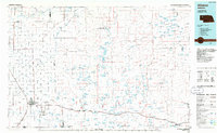 1985 Alliance1986 Print · USGSThe High Plains of Box Butte and Sheridan counties come alive in the mid-1980s, centered on the rail hub of Alliance. Genealogists and historians can trace the Burlington Northern line through small sidings and towns like Antioch, Lakeside, and Bingham near the Niobrara River.2 unique versions available
 - 1985 Map of Hemingford, 1986 Print
 1985 Hemingford1986 Print · USGSThe Nebraska panhandle comes into sharp focus during the mid-1980s, revealing a landscape of remote ranching outposts and paleontological significance. Researchers can trace the Niobrara River to the Agate Fossil Beds National Monument or locate early settlements like Nonpareil and Marsland.2 unique versions available
 - 1989 Map of Jesse Lke
 1989 Jesse Lke1989 Print · USGSSheridan County's unique Sandhills geography is captured here in the late eighties, showing the remote settlement of Hoffland. Researchers can trace the drainage of Snake Creek and locate several named basins including Jesse Lake and Lee Sturgeon Lake.
 - 1989 Map of Skunk Lake SW
 1989 Skunk Lake SW1989 Print · USGSSheridan and Box Butte counties are shown here in the late eighties, dominated by expansive ranching operations. Genealogists and local historians can trace family landholdings like the K Messersmith Ranch and Twin Lakes Ranch or locate the site of School No 100.
 - 1989 Map of Krause Lake West
 1989 Krause Lake West1989 Print · USGSThe Nebraska Sandhills come into focus along the border of Box Butte and Sheridan counties in the late 1980s. Researchers can trace the section-line roads and unique water features of this ranching country, including Twin Lakes, Krause Lake, and the southern Fenner Lakes.
 - 1989 Map of Skunk Lake NW
 1989 Skunk Lake NW1989 Print · USGSThe Nebraska Panhandle's high plains and river valleys are captured here in the late 1980s. Researchers can trace the sophisticated irrigation network of the Sturgeon Canal and the meandering course of Box Butte Creek.
End of results
Showing maps 1-14 of 14
Top cities of Box Butte County
Frequently asked questions
- What are the different types of historical maps available for Box Butte County?
- What is the oldest map of Box Butte County?
- Where can I purchase historical maps of Box Butte County for my home or office?
- Where can I download high-res historical maps of Box Butte County?
- Are there historical topographic maps available for Box Butte County?
- Is there historical aerial imagery available for Box Butte County?
- Where are historical maps of Box Butte County sourced from?