1800s (19th Century) Maps of Hamilton County, Nebraska
Explore 7 historic maps of Hamilton County from the 1800s (19th Century). These maps offer a rare glimpse into what life looked like during the 1800s — showing old roads, neighborhoods, homes, and landmarks that have changed or disappeared over time.
Whether you're researching your family's past, planning a metal detecting trip, or studying how Hamilton County's landscape evolved across the 1800s, these high-resolution maps are a powerful tool for exploring the history of this region.
- Focus on a specific era: All maps on this page are from the 1800s, giving you a focused view of this time period.
- See what’s changed: Compare century-old streets, trails, and buildings to today's modern landscape using overlays and satellite layers.
- Research with precision: Use these maps for genealogy, historical research, land use analysis, or educational projects.
- View, download, or print: Maps are fully viewable online in high resolution, and can be downloaded or printed for your own records.
Start exploring Hamilton County's history through authentic maps from the 1800s. This is your window into the past.
Hamilton County, NE maps
(7)- 1892 Map of Grand Island
 1892 Grand Island1892 Print · USGSGrand Island and the surrounding Hall County prairies are captured in the late nineteenth century as a vital rail junction. Genealogists and historians can trace early track layouts of the Union Pacific R. R. and locate old settlements like Alda and Doniphan.
 - 1895 Map of Grand Island
 1895 Grand Island1895 Print · USGSGrand Island emerged as a vital rail crossroads in central Nebraska during the late nineteenth century. Genealogists and historians can trace the early development of the city grid and surrounding settlements like Alda and Doniphan, or locate crossings such as the Island Bridge.
 - 1896 Map of Stromsburg
 1896 Stromsburg1896 Print · USGSEast-central Nebraska comes into focus during the late nineteenth-century rail boom, following the vital corridors of the Platte and Loup Rivers. Researchers can trace early township developments and the paths of the Union Pacific R. R. through Stromsburg, Fullerton, and Central City.5 unique versions available
 - 1898 Map of York
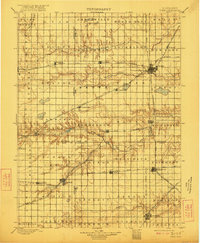
 1898 York1898 Print · USGSIn the late 1890s, the Nebraska plains were defined by a massive expansion of competing rail lines and growing farm towns. Trace the early township grids and historic rail hubs like York, Sutton, and the river crossing at McCool.4 unique versions available
 - 1898 Map of Grand Island
 1898 Grand Island1898 Print · USGSCentral Nebraska is captured in the late 1890s as a bustling rail and agricultural crossroads centered on the Platte River. Genealogists and historians can trace early settlements like Doniphan and Harvard or the grounds of the Insane Asylum outside Hastings.4 unique versions available
 - 1899 Map of St. Paul
 1899 St. Paul1899 Print · USGSCentral Nebraska's river valleys and rail hubs are preserved here during the expansion of the late 1890s. Researchers can trace the development of St. Paul and Central City alongside curious landmarks like Mumpumpey Hill and the Burlington and Missouri River R. R.4 unique versions available
 - 1899 Map of York, 1922 Print
 1899 York1922 Print · USGSSoutheast Nebraska was a burgeoning hub of rail and river commerce in the 1890s as homesteads solidified into permanent townships. Genealogists can trace family roots through early rail stops like Saronville, Lushton, and the county seats of York and Geneva.
End of results
Showing maps 1-7 of 7
Top cities of Hamilton County
- Aurora historical maps
- Hampton historical maps
- Giltner historical maps
- Phillips historical maps
- Marquette historical maps
- Hordville historical maps
See more
Frequently asked questions
- What are the different types of historical maps available for Hamilton County?
- What is the oldest map of Hamilton County?
- Where can I purchase historical maps of Hamilton County for my home or office?
- Where can I download high-res historical maps of Hamilton County?
- Are there historical topographic maps available for Hamilton County?
- Is there historical aerial imagery available for Hamilton County?
- Where are historical maps of Hamilton County sourced from?