1960s Maps of Otoe, Nebraska
Explore 2 historic maps of Otoe from the 1960s. These maps offer a rare glimpse into what life looked like during the 1960s — showing old roads, neighborhoods, homes, and landmarks that have changed or disappeared over time.
Whether you're researching your family's past, planning a metal detecting trip, or studying how Otoe's landscape evolved across the 1960s, these high-resolution maps are a powerful tool for exploring the history of this region.
- Focus on a specific era: All maps on this page are from the 1960s, giving you a focused view of this time period.
- See what’s changed: Compare century-old streets, trails, and buildings to today's modern landscape using overlays and satellite layers.
- Research with precision: Use these maps for genealogy, historical research, land use analysis, or educational projects.
- View, download, or print: Maps are fully viewable online in high resolution, and can be downloaded or printed for your own records.
Start exploring Otoe's history through authentic maps from the 1960s. This is your window into the past.
Otoe, NE maps
(2)- 1966 Map of Dunbar
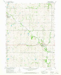 1966 Dunbar1966 Print · USGSOtoe County in the mid-1960s reveals a prairie landscape of river-valley settlements and rural school districts. Genealogists can trace family roots at Union Cem, locate the Smallfoot Sch, or follow the Chicago Burlington and Quincy rail line.
 - 1966 Map of Syracuse, 1968 Print
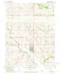 1966 Syracuse1968 Print · USGSSyracuse and Otoe thrive as rail-connected farming hubs in the mid-1960s, framed by the meandering Little Nemaha River. Researchers can trace the legacy of rural education and industry through sites like School No 10, several Quarries, and the Warner Cem.
End of results
Showing maps 1-2 of 2
Top cities near Otoe
- Syracuse historical maps
- Weeping Water historical maps
- Elmwood historical maps
- Murray historical maps
- Unadilla historical maps
- Cook historical maps
See more
Frequently asked questions
- What are the different types of historical maps available for Otoe?
- What is the oldest map of Otoe?
- Where can I purchase historical maps of Otoe for my home or office?
- Where can I download high-res historical maps of Otoe?
- Are there historical topographic maps available for Otoe?
- Is there historical aerial imagery available for Otoe?
- Where are historical maps of Otoe sourced from?