1970s Maps of McCook, Nebraska
Explore 3 historic maps of McCook from the 1970s. These maps offer a rare glimpse into what life looked like during the 1970s — showing old roads, neighborhoods, homes, and landmarks that have changed or disappeared over time.
Whether you're researching your family's past, planning a metal detecting trip, or studying how McCook's landscape evolved across the 1970s, these high-resolution maps are a powerful tool for exploring the history of this region.
- Focus on a specific era: All maps on this page are from the 1970s, giving you a focused view of this time period.
- See what’s changed: Compare century-old streets, trails, and buildings to today's modern landscape using overlays and satellite layers.
- Research with precision: Use these maps for genealogy, historical research, land use analysis, or educational projects.
- View, download, or print: Maps are fully viewable online in high resolution, and can be downloaded or printed for your own records.
Start exploring McCook's history through authentic maps from the 1970s. This is your window into the past.
McCook, NE maps
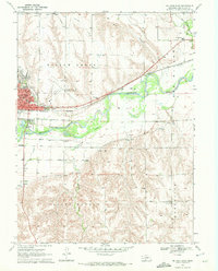
(3)- 1970 Map of McCook West, 1972 Print
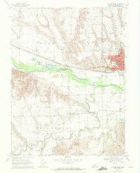 1970 McCook West1972 Print · USGSThe Republican River valley thrived during the 1970s as a hub of irrigation and rail transport. Genealogists and historians can trace local landmarks like Memorial Park Cem, the rural School No 16, and the industrial Gravel Pits.2 unique versions available
 - 1970 Map of McCook East, 1972 Print
 1970 McCook East1972 Print · USGSMcCook and the surrounding Republican River valley are captured in the early seventies during a period of established rail and irrigation growth. Local historians can trace institutional roots at McCook College or locate rural landmarks like St John Cem and School No 31.2 unique versions available
 - 1979 Map of McCook
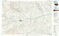 1979 McCook1979 Print · USGSThe Republican River valley of southwest Nebraska is seen here in the late seventies, a region of rail-connected river towns and extensive irrigation. Genealogists and local historians can trace family ties through McCook, the Burlington Northern line, and water landmarks like Medicine Creek.
End of results
Showing maps 1-3 of 3
Top cities near McCook
Top neighborhoods of McCook
Frequently asked questions
- What are the different types of historical maps available for McCook?
- What is the oldest map of McCook?
- Where can I purchase historical maps of McCook for my home or office?
- Where can I download high-res historical maps of McCook?
- Are there historical topographic maps available for McCook?
- Is there historical aerial imagery available for McCook?
- Where are historical maps of McCook sourced from?