1990s Maps of Fort Crook, Bellevue
Explore 2 historic maps of Fort Crook from the 1990s. These maps offer a rare glimpse into what life looked like during the 1990s — showing old roads, neighborhoods, homes, and landmarks that have changed or disappeared over time.
Whether you're researching your family's past, planning a metal detecting trip, or studying how Fort Crook's landscape evolved across the 1990s, these high-resolution maps are a powerful tool for exploring the history of this region.
- Focus on a specific era: All maps on this page are from the 1990s, giving you a focused view of this time period.
- See what’s changed: Compare century-old streets, trails, and buildings to today's modern landscape using overlays and satellite layers.
- Research with precision: Use these maps for genealogy, historical research, land use analysis, or educational projects.
- View, download, or print: Maps are fully viewable online in high resolution, and can be downloaded or printed for your own records.
Start exploring Fort Crook's history through authentic maps from the 1990s. This is your window into the past.
Fort Crook, Bellevue maps
(2)- 1994 Map of Plattsmouth
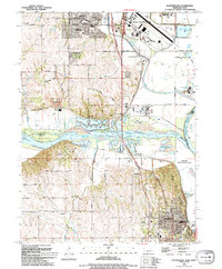 1994 Plattsmouth1994 Print · USGSEastern Nebraska's river valley comes alive in the mid-nineties as the Platte River meets the Missouri near the growing hub of Plattsmouth. Researchers can trace the layout of Offutt Air Force Base, find family names at Oak Hill Cemetery, or locate local schools like Peter Sarpy School.
 - 1994 Map of Omaha South, 1995 Print
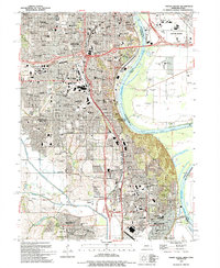 1994 Omaha South1995 Print · USGSOmaha and Bellevue thrive along the Missouri River in the mid-nineties, showing a landscape defined by military aviation and dense neighborhood history. Researchers can trace local roots through numerous sites like St Johns Cem, Rosenblatt Stadium, and the extensive grounds of Offutt Air Force Base.
End of results
Showing maps 1-2 of 2
Frequently asked questions
- What are the different types of historical maps available for Fort Crook?
- What is the oldest map of Fort Crook?
- Where can I purchase historical maps of Fort Crook for my home or office?
- Where can I download high-res historical maps of Fort Crook?
- Are there historical topographic maps available for Fort Crook?
- Is there historical aerial imagery available for Fort Crook?
- Where are historical maps of Fort Crook sourced from?