Old Maps of Seward County, Nebraska for Academic Research
Study the evolution of Seward County with 99 high-resolution historic maps. Whether you're teaching, researching, or modeling changes in land use, these maps provide essential visual documentation of urban, environmental, and geographic change.
- Analyze long-term change: Track patterns in development, transportation, and natural features.
- Ideal for environmental or urban studies: Support academic projects with primary historical map data.
- Use in the classroom or lab: Educators and researchers rely on these maps to bring historical context to life.
These maps are a powerful tool for teaching, research, and visualizing how Seward County has changed over the decades.
Seward County, NE maps
(99)- 1897 Map of Lincoln
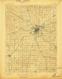 1897 Lincoln1897 Print · USGSLate-Victorian Nebraska comes into focus here as a bustling hub of steam and steel, centered on the capital. You can trace the early layouts of University Place and Bethany or locate rural landmarks like the Asylum, Lincoln Salt Lake, and the rail stop at Prairie Home.4 unique versions available
 - 1899 Map of Wahoo
 1899 Wahoo1899 Print · USGSSaunders County and its neighbors thrive as a booming rail hub in the 1890s, where the Platte River meets a dense web of iron tracks. Trace the early development of prairie towns like Wahoo, Valparaiso, and the Bohemian settlement at Prague.3 unique versions available
 - 1899 Map of David City
 1899 David City1899 Print · USGSButler County and its neighbors flourished during the late nineteenth-century railroad boom, centered on the junction at David City. Genealogists and historians can trace the early footprints of Surprise, Wayland, and Rising along the extensive steam rail networks.3 unique versions available
 - 1934 Map of Seward
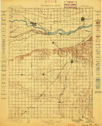
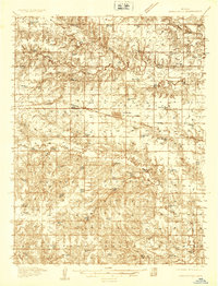
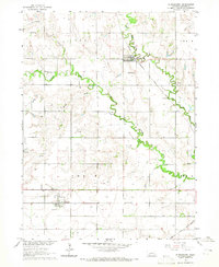
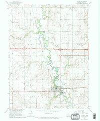
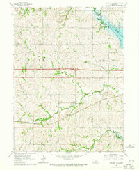
 1934 Seward1934 Print · USGSSeward County at the height of the mid-thirties reveals a landscape of thriving river towns and essential rail connections. Genealogists and historians can trace numerous rural districts from School No 87 to the Old Soldiers and Sailors Home and Perry Mound Cem.
 - 1934 Map of Utica, 1961 Print
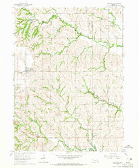
 1934 Utica1961 Print · USGSThe Seward County plains in the 1930s reveal a landscape of small towns and rural school districts connected by the Chicago and Northwestern. Trace family history at Prairie Grove Cem or locate forgotten sites like Midget Sch and the Flowing Well.2 unique versions available
 - 1935 Map of Dorchester
 1935 Dorchester1935 Print · USGSSaline County agricultural life is frozen in time during the mid-1930s, centered on the railroad town of Dorchester. Genealogists and historians can trace dozens of country school sites like Red Brick Sch and family-named landmarks like Gilbert Cem.
 - 1937 Map of Utica
 1937 Utica1937 Print · USGSThe Seward County plains are captured in the mid-1930s, showing a landscape defined by rail lines and rural school districts. Genealogists can locate family landmarks like Prairie Grove Cem and numerous schools such as Rosemound Sch and Kinkaid Sch.2 unique versions available
 - 1939 Map of Seward
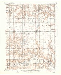
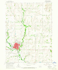
 1939 Seward1939 Print · USGSSeward County in the mid-1930s shows a thriving network of rail-side towns and rural school districts at the heart of the Nebraska plains. Genealogists and local historians can trace hundreds of farmstead locations and community anchors like Old Salem Cem, Evangelical Ch, and Goehner.3 unique versions available
 - 1940 Map of Dorchester
 1940 Dorchester1940 Print · USGSSaline County and Seward County farm country is shown here in the mid-1930s, when small district schools and rural halls anchored every township. Genealogists can locate family landmarks like Gilbert Cem, Tabor Hall, and the West Blue Ch church.3 unique versions available
 - 1955 Map of Fremont, 1966 Print
 1955 Fremont1966 Print · USGSEastern Nebraska and the Missouri River border are captured during the mid-fifties, just as the interstate system began to emerge. Researchers can trace the development of Omaha, locate the sprawling Offutt Air Force Base, or study the river-bound ecology of the De Soto National Wildlife Refuge.3 unique versions available
 - 1955 Map of Lincoln, 1967 Print
 1955 Lincoln1967 Print · USGSSoutheast Nebraska in the mid-fifties presents a landscape of thriving railroad towns and the expanding footprint of the capital city. Researchers can trace the legacy of the pioneer era at the Homestead National Monument of America or locate mid-century military infrastructure like Lincoln Air Force Base.5 unique versions available
 - 1957 Map of Fremont
 1957 Fremont1957 Print · USGSEastern Nebraska and western Iowa thrive along the Platte and Missouri rivers during the mid-fifties. Genealogists can locate small rural schools like Fairview School and tracing the paths of the Union Pacific through towns like Albion and Humphrey.
 - 1957 Map of Lincoln
 1957 Lincoln1957 Print · USGSSoutheastern Nebraska at mid-century shows a landscape of thriving rail towns and expanding infrastructure centered on Lincoln. Researchers can trace the path of the Chicago Burlington and Quincy railroad through communities like Weeping Water, Fairmont, and Seward.
 - 1958 Map of Fremont
 1958 Fremont1958 Print · USGSEastern Nebraska in the late fifties is captured here as a thriving corridor of river-valley commerce and rail transport. Researchers can trace the development of Omaha and Fremont or locate local landmarks like Midland College and Offutt Air Force Base.
 - 1958 Map of Lincoln
 1958 Lincoln1958 Print · USGSSoutheast Nebraska at the end of the 1950s shows a region defined by agricultural trade and the expansion of the state capital. Genealogists can trace family footprints across the Blue Valley and locate landmarks like the Lincoln AFB or the U.S. Veterans Hospital.
 - 1964 Map of Staplehurst, 1965 Print
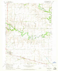
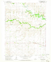
 1964 Staplehurst1965 Print · USGSSeward County farming life and rail transit are captured here in the mid-sixties. Local historians can trace established homesteads near Staplehurst and Tamora, and locate rural landmarks like Zion Sch or the American Cem.
 - 1964 Map of Goehner, 1965 Print
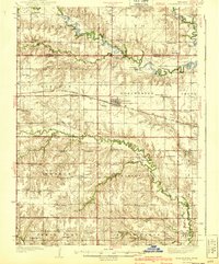
 1964 Goehner1965 Print · USGSIn the mid-1960s, Seward County saw the arrival of the interstate era while maintaining its deep-rooted rural character. Genealogists can trace family landmarks like Old Salem Cem Salem Ch, Perry Mound Cem, and the Star Sch schoolhouse.2 unique versions available
 - 1964 Map of Crete North, 1965 Print
 1964 Crete North1965 Print · USGSSaline County and the surrounding plains are captured in the mid-1960s as the riverfront community of Crete expands. Genealogists and local historians can trace rural school sites like Valley View Sch and the rail-side settlement of Berks along the Chicago Burlington and Quincy line.2 unique versions available
 - 1964 Map of Dorchester, 1965 Print
 1964 Dorchester1965 Print · USGSThe rural landscape of Saline and Seward counties is captured here in the mid-1960s, centered on the settlement of Dorchester. Local historians can trace the legacy of pioneer education and community at Goldhammer Cem, Star Sch, and West Blue Ch.
 - 1964 Map of Milford, 1965 Print
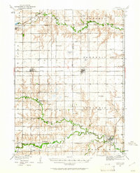
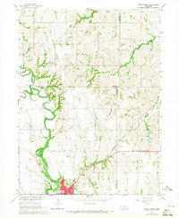
 1964 Milford1965 Print · USGSSeward County's river valley is caught in a moment of transition during the mid-1960s as new infrastructure arrives. You can trace the path of the Chicago Burlington and Quincy railroad or locate local landmarks like Milford Mennonite Cem and Horseshoe Lake.2 unique versions available
 - 1964 Map of Garland, 1965 Print
 1964 Garland1965 Print · USGSSeward County's agricultural and rail landscape is meticulously detailed in the mid-sixties, centered on the village of Garland. Researchers can locate historic rural sites including Germantown Cem, Immanuel Sch, and the junction of the Chicago and North Western railroad.2 unique versions available
 - 1964 Map of Seward, 1965 Print
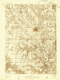
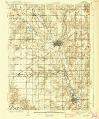
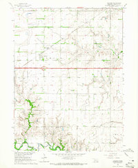
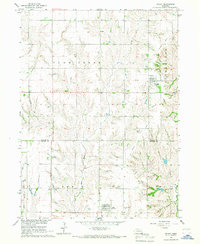
 1964 Seward1965 Print · USGSSeward at the height of the mid-sixties reveals a bustling college town and rail hub in the heart of Nebraska's river country. Genealogists and researchers can trace local roots at Greenwood Cem or locate rural landmarks like Hells Corner Sch and School No 9.
 - 1964 Map of Dorchester NW, 1965 Print
 1964 Dorchester NW1965 Print · USGSSoutheast Nebraska farmland is charted here in the mid-1960s, showing the intersection of the Seward and Saline county lines. Genealogists can locate rural burials at Englehaupt Cem and West Mills Cem or trace the route of the Chicago Burlington and Quincy railroad.
 - 1964 Map of Pleasant Dale, 1965 Print
 1964 Pleasant Dale1965 Print · USGSPleasant Dale and the surrounding prairie of eastern Nebraska are shown here in the mid-sixties as new reservoirs reshaped the landscape. Genealogists and local historians can trace family locations near Zion Ch, Burd Sch, and the Pleasant Dale Cem.2 unique versions available
 - 1966 Map of Dwight, 1967 Print
 1966 Dwight1967 Print · USGSButler and Seward Counties appear in the mid-1960s as a productive agricultural landscape defined by small villages and creek drainages. You can trace early settlement patterns through St Marys Cem, the Old Railroad Grade, and the village of Dwight.
Showing maps 1-25 of 99
Top cities of Seward County
- Seward historical maps
- Milford historical maps
- Utica historical maps
- Beaver Crossing historical maps
- Staplehurst historical maps
- Garland historical maps
See more
Frequently asked questions
- What are the different types of historical maps available for Seward County?
- What is the oldest map of Seward County?
- Where can I purchase historical maps of Seward County for my home or office?
- Where can I download high-res historical maps of Seward County?
- Are there historical topographic maps available for Seward County?
- Is there historical aerial imagery available for Seward County?
- Where are historical maps of Seward County sourced from?