1940s Maps of Seward County, Nebraska
Explore 1 historic maps of Seward County from the 1940s. These maps offer a rare glimpse into what life looked like during the 1940s — showing old roads, neighborhoods, homes, and landmarks that have changed or disappeared over time.
Whether you're researching your family's past, planning a metal detecting trip, or studying how Seward County's landscape evolved across the 1940s, these high-resolution maps are a powerful tool for exploring the history of this region.
- Focus on a specific era: All maps on this page are from the 1940s, giving you a focused view of this time period.
- See what’s changed: Compare century-old streets, trails, and buildings to today's modern landscape using overlays and satellite layers.
- Research with precision: Use these maps for genealogy, historical research, land use analysis, or educational projects.
- View, download, or print: Maps are fully viewable online in high resolution, and can be downloaded or printed for your own records.
Start exploring Seward County's history through authentic maps from the 1940s. This is your window into the past.
Seward County, NE maps
(1)- 1940 Map of Dorchester
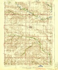 1940 Dorchester1940 Print · USGSSaline County and Seward County farm country is shown here in the mid-1930s, when small district schools and rural halls anchored every township. Genealogists can locate family landmarks like Gilbert Cem, Tabor Hall, and the West Blue Ch church.3 unique versions available
End of results
Showing maps 1-1 of 1
Top cities of Seward County
- Seward historical maps
- Milford historical maps
- Utica historical maps
- Beaver Crossing historical maps
- Staplehurst historical maps
- Garland historical maps
See more
Frequently asked questions
- What are the different types of historical maps available for Seward County?
- What is the oldest map of Seward County?
- Where can I purchase historical maps of Seward County for my home or office?
- Where can I download high-res historical maps of Seward County?
- Are there historical topographic maps available for Seward County?
- Is there historical aerial imagery available for Seward County?
- Where are historical maps of Seward County sourced from?