1960s Maps of Grover, Nebraska
Explore 1 historic maps of Grover from the 1960s. These maps offer a rare glimpse into what life looked like during the 1960s — showing old roads, neighborhoods, homes, and landmarks that have changed or disappeared over time.
Whether you're researching your family's past, planning a metal detecting trip, or studying how Grover's landscape evolved across the 1960s, these high-resolution maps are a powerful tool for exploring the history of this region.
- Focus on a specific era: All maps on this page are from the 1960s, giving you a focused view of this time period.
- See what’s changed: Compare century-old streets, trails, and buildings to today's modern landscape using overlays and satellite layers.
- Research with precision: Use these maps for genealogy, historical research, land use analysis, or educational projects.
- View, download, or print: Maps are fully viewable online in high resolution, and can be downloaded or printed for your own records.
Start exploring Grover's history through authentic maps from the 1960s. This is your window into the past.
Grover, NE maps
(1)- 1964 Map of Milford, 1965 Print
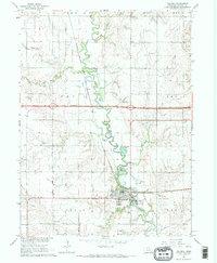 1964 Milford1965 Print · USGSSeward County's river valley is caught in a moment of transition during the mid-1960s as new infrastructure arrives. You can trace the path of the Chicago Burlington and Quincy railroad or locate local landmarks like Milford Mennonite Cem and Horseshoe Lake.2 unique versions available
End of results
Showing maps 1-1 of 1
Top cities near Grover
- Seward historical maps
- Crete historical maps
- Milford historical maps
- Dorchester historical maps
- Malcolm historical maps
- Staplehurst historical maps
See more
Frequently asked questions
- What are the different types of historical maps available for Grover?
- What is the oldest map of Grover?
- Where can I purchase historical maps of Grover for my home or office?
- Where can I download high-res historical maps of Grover?
- Are there historical topographic maps available for Grover?
- Is there historical aerial imagery available for Grover?
- Where are historical maps of Grover sourced from?