1970s Maps of Harrison, Bowen Precinct
Explore 2 historic maps of Harrison from the 1970s. These maps offer a rare glimpse into what life looked like during the 1970s — showing old roads, neighborhoods, homes, and landmarks that have changed or disappeared over time.
Whether you're researching your family's past, planning a metal detecting trip, or studying how Harrison's landscape evolved across the 1970s, these high-resolution maps are a powerful tool for exploring the history of this region.
- Focus on a specific era: All maps on this page are from the 1970s, giving you a focused view of this time period.
- See what’s changed: Compare century-old streets, trails, and buildings to today's modern landscape using overlays and satellite layers.
- Research with precision: Use these maps for genealogy, historical research, land use analysis, or educational projects.
- View, download, or print: Maps are fully viewable online in high resolution, and can be downloaded or printed for your own records.
Start exploring Harrison's history through authentic maps from the 1970s. This is your window into the past.
Harrison, Bowen Precinct maps
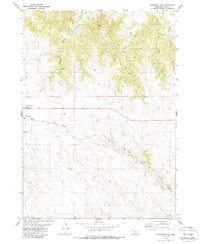
(2)- 1978 Map of Harrison West, 1979 Print
 1978 Harrison West1979 Print · USGSSioux County life in the late 1970s centers on the railroad crossroads of Harrison and the surrounding High Plains. Researchers can trace the Chicago and North Western line, locate the Cem, and see the layout of the County Fairground.
 - 1979 Map of Harrison East, 1988 Print
 1979 Harrison East1988 Print · USGSNear the high Nebraska border in the late seventies, this survey captures a vital rail and ranching landscape. Genealogists and local historians can trace the foundations of Harrison and locate family names at Harrison Cem or St Mary Cem along the Chicago and North Western line.
End of results
Showing maps 1-2 of 2
Top cities near Harrison
Frequently asked questions
- What are the different types of historical maps available for Harrison?
- What is the oldest map of Harrison?
- Where can I purchase historical maps of Harrison for my home or office?
- Where can I download high-res historical maps of Harrison?
- Are there historical topographic maps available for Harrison?
- Is there historical aerial imagery available for Harrison?
- Where are historical maps of Harrison sourced from?