1960s Maps of Sheep Creek Precinct, Nebraska
Explore 6 historic maps of Sheep Creek Precinct from the 1960s. These maps offer a rare glimpse into what life looked like during the 1960s — showing old roads, neighborhoods, homes, and landmarks that have changed or disappeared over time.
Whether you're researching your family's past, planning a metal detecting trip, or studying how Sheep Creek Precinct's landscape evolved across the 1960s, these high-resolution maps are a powerful tool for exploring the history of this region.
- Focus on a specific era: All maps on this page are from the 1960s, giving you a focused view of this time period.
- See what’s changed: Compare century-old streets, trails, and buildings to today's modern landscape using overlays and satellite layers.
- Research with precision: Use these maps for genealogy, historical research, land use analysis, or educational projects.
- View, download, or print: Maps are fully viewable online in high resolution, and can be downloaded or printed for your own records.
Start exploring Sheep Creek Precinct's history through authentic maps from the 1960s. This is your window into the past.
Sheep Creek Precinct, NE maps
(6)- 1963 Map of Chalk Buttes, 1965 Print
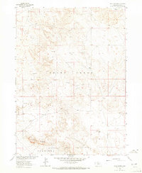 1963 Chalk Buttes1965 Print · USGSSioux County ranching country is captured here during the mid-twentieth century as part of the Missouri River Basin development program. Researchers can locate family landmarks like Hatch Ranch and Spurior Place alongside remote water sources like Goodman Windmill.
 - 1963 Map of Torrington SE, 1965 Print
 1963 Torrington SE1965 Print · USGSThe high plains of the Wyoming-Nebraska border are captured here in the early 1960s, showing the intersection of pioneer history and modern irrigation. Researchers can trace the path of the Emigrant Trail near the North Platte River and locate local sites like Hunton Meadows and Henry.
 - 1963 Map of Erdman Ranch, 1965 Print
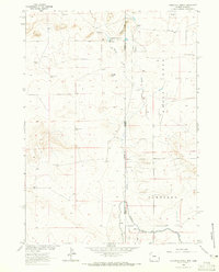
 1963 Erdman Ranch1965 Print · USGSHigh plains ranching and intricate canal irrigation meet along the Sioux and Scotts Bluff county line in the early sixties. Genealogists and historians can locate the Erdman Ranch, the Spottedtail Community Hall, and family-named landmarks like the Selby Windmill.
 - 1963 Map of Dry Sheep Creek, 1965 Print
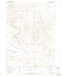
 1963 Dry Sheep Creek1965 Print · USGSSioux and Scotts Bluff counties are shown at the height of their mid-century irrigation boom, where the High Plains were transformed by an expansive canal network. Researchers can trace family-named landmarks like Springer Ranch and rural centers such as Roach and Pleasant Grove Ch.
 - 1963 Map of Carpenter Ranch, 1965 Print
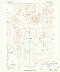
 1963 Carpenter Ranch1965 Print · USGSThe Wyoming and Nebraska high plains are captured here in the early sixties, showing a ranching landscape tied to the state line. Genealogists and historians can locate family outposts like Duncan Place, James, and numerous named water points including Wildy Windmill.2 unique versions available
 - 1963 Map of University Lake, 1965 Print
 1963 University Lake1965 Print · USGSSioux County ranching country is captured in the early sixties as the irrigation networks of the High Plains were fully established. Researchers can trace historic family operations like Wind Springs Ranch and F-X Ranch or locate early water features such as University Lake.
End of results
Showing maps 1-6 of 6
Top cities near Sheep Creek Precinct
Top neighborhoods of Sheep Creek Precinct
Frequently asked questions
- What are the different types of historical maps available for Sheep Creek Precinct?
- What is the oldest map of Sheep Creek Precinct?
- Where can I purchase historical maps of Sheep Creek Precinct for my home or office?
- Where can I download high-res historical maps of Sheep Creek Precinct?
- Are there historical topographic maps available for Sheep Creek Precinct?
- Is there historical aerial imagery available for Sheep Creek Precinct?
- Where are historical maps of Sheep Creek Precinct sourced from?