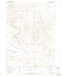
1963 Map of University Lake
USGS Topo · Published 1965About this map
The High Plains of Sioux County, Nebraska, are defined here by a network of ranching outposts and vital water management infrastructure. University Lake serves as a central landmark in this 1960s landscape, situated just north of the Interstate Canal and the Main Interstate Canal. These engineering features reflect the era's focus on irrigation and land development in the Missouri River Basin. The terrain is marked by distinctive formations like the Horseshoe and the Hat, while local water sources are meticulously documented through named wells such as Samson Well and Claypit Well. Settled life is represented by several legacy operations, including the Point Option Ranch, F-X Ranch, and Wind Springs Ranch. In the north, the winding course of Spottedtail Creek cuts through the high country, providing a natural contrast to the straight-line precision of the canals and the surrounding township boundaries of Fanning and Funston.
Find a feature on this map
24 named features on this map. Tap any name to fly to it.
Don’t see what you’re looking for? This feature index may not catch every label — zoom into the map to look around manually.
Map Details
Editions of this 1963 University Lake Map
This is the sole edition of this map. No revisions or reprints were ever made.
Other maps of this area

1898 · Scotts Bluff
USGS Topo · 1:125,000

1899 · Whistle Creek
USGS Topo · 1:125,000

1954 · Scottsbluff
USGS Topo · 1:250,000

1955 · Alliance
USGS Topo · 1:250,000

1957 · Alliance
USGS Topo · 1:250,000

1958 · Alliance
USGS Topo · 1:250,000

1958 · Scottsbluff
USGS Topo · 1:250,000

1963 · Mitchell
USGS Topo · 1:24,000

1963 · Scottsbluff North
USGS Topo · 1:24,000
1963 · Erdman Ranch
USGS Topo · 1:24,000