
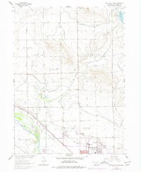
1963 Map of Scottsbluff North
USGS Topo · Published 1965About this map
The irrigation-rich landscape of the Nebraska Panhandle comes into sharp focus north of Scottsbluff in the early 1960s. This agricultural economy is defined by a complex network of waterways, including the Interstate Canal, Tri-State Canal, and Perry Canal, which draw from the North Platte River. Small communities and rail stops like Mintle, Covert, and Heldt follow the Chicago Burlington and Quincy railroad line, serving as vital links between the rural sections and the growing city center.
Find a feature on this map
45 named features on this map. Tap any name to fly to it.
Don’t see what you’re looking for? This feature index may not catch every label — zoom into the map to look around manually.
Map Details
Editions of this 1963 Scottsbluff North Map
2 editions found
Other maps of this area

1898 · Scotts Bluff
USGS Topo · 1:125,000

1899 · Whistle Creek
USGS Topo · 1:125,000

1954 · Scottsbluff
USGS Topo · 1:250,000

1955 · Alliance
USGS Topo · 1:250,000

1957 · Alliance
USGS Topo · 1:250,000

1958 · Alliance
USGS Topo · 1:250,000

1958 · Scottsbluff
USGS Topo · 1:250,000

1963 · Scottsbluff South
USGS Topo · 1:24,000

1963 · Mitchell
USGS Topo · 1:24,000
1963 · Erdman Ranch
USGS Topo · 1:24,000