
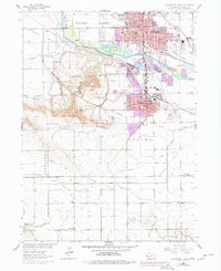
1963 Map of Scottsbluff South
USGS Topo · Published 1965About this map
The North Platte River serves as the dividing line between the growing mid-century urban centers of Scottsbluff and Gering in this 1960s study. The landscape is dominated by the dramatic uplift of the Scotts Bluff National Monument, featuring named formations like Eagle Rock, Sentinel Rock, and Dome Rock. The map meticulously charts the intricate irrigation network essential to the region, including the Fort Laramie Canal and Mitchell Canal, which transformed this high plains terrain into a productive agricultural valley. To the south, the Cedar Valley Oil Field indicates the industrial diversification of the era. Historical transit corridors are well-preserved here, specifically the Emigrant Trail winding through Mitchell Pass, providing a window into the overland migration routes that once defined the Western expansion. Local institutions, from Junior College to the Cedar Valley Chapel, reflect the established social fabric of these Nebraska communities.
Find a feature on this map
77 named features on this map. Tap any name to fly to it.
Don’t see what you’re looking for? This feature index may not catch every label — zoom into the map to look around manually.
Map Details
Editions of this 1963 Scottsbluff South Map
2 editions found
Other maps of this area

1898 · Scotts Bluff
USGS Topo · 1:125,000

1954 · Scottsbluff
USGS Topo · 1:250,000

1958 · Scottsbluff
USGS Topo · 1:250,000

1963 · Mitchell
USGS Topo · 1:24,000

1963 · Scottsbluff North
USGS Topo · 1:24,000

1963 · Roubadeau Pass
USGS Topo · 1:24,000

1965 · Minatare
USGS Topo · 1:24,000
1965 · Lake Alice
USGS Topo · 1:24,000

1973 · Scotts Bluff 4 NW
USGS Topo · 1:24,000

1973 · Scotts Bluff 4 NE
USGS Topo · 1:24,000